IMAGES TAKEN NEAR TO
Lea Terrace, BIDEFORD, EX39 1PZ
Introduction
This page details the photographs taken nearby to Lea Terrace, EX39 1PZ by members of the Geograph project.
The Geograph project started in 2005 with the aim of publishing, organising and preserving representative images for every square kilometre of Great Britain, Ireland and the Isle of Man.

There are currently over 7.5m images from over14,400 individuals and you can help contribute to the project by visiting https://www.geograph.org.uk
Image Map (Loading...)


Getting Data...Please wait
Leaflet Map data © OpenStreetMap
Images are licensed for reuse under creativecommons.org/licenses/by-sa/2.0
Notes
- Clicking on the map will re-center to the selected point.
- The higher the marker number, the further away the image location is from the centre of the postcode.
Image Listing (89 Images Found)
Images are licensed for reuse under creativecommons.org/licenses/by-sa/2.0
Image
Details
Distance
1
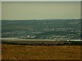
Bideford, Northam & Appledore as seen from the junction of Aylescott Lane & the A3123
Bideford is to the left. Just right of centre is Appledore while Northam lies behind Appledore.
Image: © Roger A Smith
Taken: 28 Sep 2009
0.07 miles
2
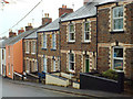
Stepped terraced houses of local stone and two-tone brick, Myrtle Street, Appledore
Myrtle Street is part of the main road into the village.
Image: © Robin Stott
Taken: 29 Apr 2014
0.11 miles

4

Ordnance Survey Cut Mark
This OS cut mark can be found on No29 Myrtle Street. It marks a point 17.837m above mean sea level.
Image: © Adrian Dust
Taken: 14 Feb 2017
0.11 miles
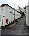
5

Appledore Fire Station
Appledore Fire Station, Myrtle Street, Appledore, Devon.
Image: © Kevin Hale
Taken: 10 Jul 1995
0.12 miles
6

Ordnance Survey Cut Mark
This OS cut mark can be found on the south side of Myrtle Street. It marks a point 8.001m above mean sea level.
Image: © Adrian Dust
Taken: 14 Feb 2017
0.12 miles
7

Ordnance Survey Cut Mark
This OS cut mark can be found on the wall of No1 Richmond. It marks a point 29.486m above mean sea level.
Image: © Adrian Dust
Taken: 14 Feb 2017
0.13 miles
9
New Street, at the side of Appledore Community Hall
Unsuitable for motors, says the blue sign. The postbox number is EX39 78. The Community Hall fronts on to New Quay Street Image The main road into the village continues as Marine Parade, lower left.
Image: © Robin Stott
Taken: 29 Apr 2014
0.13 miles
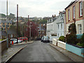
10
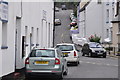
Appledore : Myrtle Street
From New Quay Street looking up along Myrtle Street.
Image: © Lewis Clarke
Taken: 1 Jun 2014
0.14 miles