IMAGES TAKEN NEAR TO
Little Torrington, TORRINGTON, EX38 8PP
Introduction
This page details the photographs taken nearby to EX38 8PP by members of the Geograph project.
The Geograph project started in 2005 with the aim of publishing, organising and preserving representative images for every square kilometre of Great Britain, Ireland and the Isle of Man.

There are currently over 7.5m images from over14,400 individuals and you can help contribute to the project by visiting https://www.geograph.org.uk
Image Map (Loading...)


Getting Data...Please wait
Leaflet Map data © OpenStreetMap
Images are licensed for reuse under creativecommons.org/licenses/by-sa/2.0
Notes
- Clicking on the map will re-center to the selected point.
- The higher the marker number, the further away the image location is from the centre of the postcode.
Image Listing (4 Images Found)
Images are licensed for reuse under creativecommons.org/licenses/by-sa/2.0
Image
Details
Distance
1
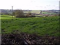
Field by the A386
A field west of Little Torrington, looking across land falling away westwards to a tributary of Langtree Lake. The trees mark the stub of what must have been a former field boundary.
Image: © Derek Harper
Taken: 30 Oct 2007
0.18 miles
2
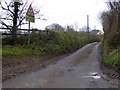
The road to Barley Hayes from Five Lane End
There is a warning about the low bridge under the former railway line, now usedby the Tarka Trail
Image: © David Smith
Taken: 23 Jan 2015
0.19 miles
3
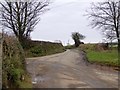
Five Lane End
Now only a crossroads, as the fifth lane is only a bridleway
Image: © David Smith
Taken: 23 Jan 2015
0.20 miles
4
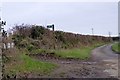
Five Lane End; the fifth lane is a bridleway
Image: © David Smith
Taken: 23 Jan 2015
0.21 miles