IMAGES TAKEN NEAR TO
Langtree, TORRINGTON, EX38 8PA
Introduction
This page details the photographs taken nearby to EX38 8PA by members of the Geograph project.
The Geograph project started in 2005 with the aim of publishing, organising and preserving representative images for every square kilometre of Great Britain, Ireland and the Isle of Man.

There are currently over 7.5m images from over14,400 individuals and you can help contribute to the project by visiting https://www.geograph.org.uk
Image Map
Images are licensed for reuse under creativecommons.org/licenses/by-sa/2.0
Notes
- Clicking on the map will re-center to the selected point.
- The higher the marker number, the further away the image location is from the centre of the postcode.
Image Listing (27 Images Found)
Images are licensed for reuse under creativecommons.org/licenses/by-sa/2.0
Image
Details
Distance
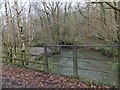
2
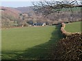
Watergate
From the green lane above Gortlage, this view looks across a converted barn and Priestacott Mill to the valley junction of Langtree Lake (left, heading through a narrow wooded valley downstream from Watergate Bridge) and the valley to the right which carries the Tarka Trail upstream.
Image: © Derek Harper
Taken: 16 Feb 2008
0.05 miles
3
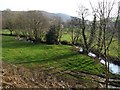
Langtree Lake
The wiggling tree-lined stream approaches Watergate Bridge across a wider floodplain that it will see until reaching the Torridge. The buildings in the background are at Priestacott Mill. Seen from the B3277 which here runs above a bank.
Image: © Derek Harper
Taken: 16 Feb 2008
0.06 miles
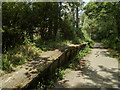
4
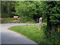
Tarka Trail crossing the road at Watergate Bridge, going south
Image: © Rob Purvis
Taken: 5 Jun 2009
0.08 miles
7
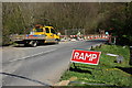
Roadworks at Watergate Bridge
The Tarka Trail and the course of a disused railway cross the road at Watergate Bridge.
Image: © Philip Halling
Taken: 18 Apr 2007
0.11 miles
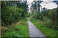
8
Watergate Halt platform, near Great Torrington
The disused railway line is now known as the 'Tarka Trail' and is popular with cyclists and walkers.
Image: © Guy Butler-Madden
Taken: 15 Jul 2013
0.11 miles
9
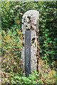
Artwork at Watergate Bridge
One of the many pieces along the Tarka Trail.
Image: © Guy Wareham
Taken: 30 Sep 2016
0.12 miles
10
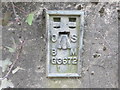
Ordnance Survey Flush Bracket G3672
This can be found on the parapet of a road (B3227) bridge at Clements Hill.
For more detail see : http://www.bench-marks.org.uk/bm2215
Image: © Peter Wood
Taken: 2 Apr 2015
0.14 miles