IMAGES TAKEN NEAR TO
Little Torrington, TORRINGTON, EX38 8NA
Introduction
This page details the photographs taken nearby to EX38 8NA by members of the Geograph project.
The Geograph project started in 2005 with the aim of publishing, organising and preserving representative images for every square kilometre of Great Britain, Ireland and the Isle of Man.

There are currently over 7.5m images from over14,400 individuals and you can help contribute to the project by visiting https://www.geograph.org.uk
Image Map
Images are licensed for reuse under creativecommons.org/licenses/by-sa/2.0
Notes
- Clicking on the map will re-center to the selected point.
- The higher the marker number, the further away the image location is from the centre of the postcode.
Image Listing (3 Images Found)
Images are licensed for reuse under creativecommons.org/licenses/by-sa/2.0
Image
Details
Distance
1
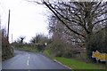
Entrances at Frizenham
Frizenham is a large farm on the hilltop west of Taddiport; the sign advertises the cattery there
Image: © David Smith
Taken: 23 Jan 2015
0.04 miles
2
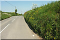
B3227 near Frizenham
Reaching the highest point on the hop over from Watergate Bridge to Great Torrington.
Image: © Derek Harper
Taken: 23 May 2018
0.15 miles
3
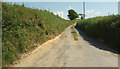
Farm lane to Bowden
From where Image] was taken, looking right. The name "Bowden" occurs frequently among Devon farms. "Old English boga ‘bow’ + dun ‘hill’, i.e. ‘hill shaped like a bow’" according to https://www.ancestry.co.uk/name-origin?surname=bowden , though it suggests other possibilities as to derivation. The private farm track has nearly 500 metres to go to reach the farm in Image
Image: © Derek Harper
Taken: 23 May 2018
0.19 miles