IMAGES TAKEN NEAR TO
TORRINGTON, EX38 8JF
Introduction
This page details the photographs taken nearby to EX38 8JF by members of the Geograph project.
The Geograph project started in 2005 with the aim of publishing, organising and preserving representative images for every square kilometre of Great Britain, Ireland and the Isle of Man.

There are currently over 7.5m images from over14,400 individuals and you can help contribute to the project by visiting https://www.geograph.org.uk
Image Map
Images are licensed for reuse under creativecommons.org/licenses/by-sa/2.0
Notes
- Clicking on the map will re-center to the selected point.
- The higher the marker number, the further away the image location is from the centre of the postcode.
Image Listing (48 Images Found)
Images are licensed for reuse under creativecommons.org/licenses/by-sa/2.0
Image
Details
Distance
1
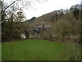
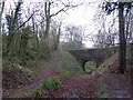
Canal Bridge, Beam
This bridge was built by Lord Rolle in 1824. Henry Williamson sited Owlery Holt, birthplace of Tarka, near to the bridge. Viewed from the Tarka Trail
Image: © Grant Sherman
Taken: 25 Jan 2005
0.09 miles
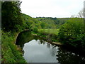
3
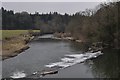
Torridge : The River Torridge
Looking down to the River Torridge from a bridge over it.
Image: © Lewis Clarke
Taken: 3 Mar 2013
0.12 miles
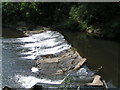
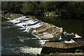
5
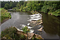
Weir on the River Torridge
Viewed from the Tarka Trail.
Image: © Guy Wareham
Taken: 7 Sep 2016
0.12 miles
7
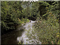
The River Torridge at Broomdown Copse
At this point the river has looped in a north easterly direction and has returned to its previous north westerly direction for a short distance.
Beam House is off to the left of the image, the A386 to the right.
Image: © Roger A Smith
Taken: 24 Aug 2016
0.12 miles
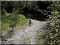
8
Tranquil Torridge 1
Looking downstream from the A386 near Beam House.
Image: © Jonathan Billinger
Taken: 13 May 2009
0.13 miles
9
Path by the former Rolle Canal
The canal, built in the early 19th century by Lord Rolle, has been cleared to provide a waymarked path. The canal was used by small tub-boats which fitted through the bridge
Image: © David Smith
Taken: 23 Jan 2015
0.13 miles
10
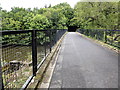
The Tarka Trail crossing the River Torridge
A good high guard fence has been erected on each side of this repurposed railway viaduct.
Image: © Tony Atkin
Taken: 1 Sep 2014
0.13 miles