IMAGES TAKEN NEAR TO
St. Giles, TORRINGTON, EX38 7EH
Introduction
This page details the photographs taken nearby to EX38 7EH by members of the Geograph project.
The Geograph project started in 2005 with the aim of publishing, organising and preserving representative images for every square kilometre of Great Britain, Ireland and the Isle of Man.

There are currently over 7.5m images from over14,400 individuals and you can help contribute to the project by visiting https://www.geograph.org.uk
Image Map
Images are licensed for reuse under creativecommons.org/licenses/by-sa/2.0
Notes
- Clicking on the map will re-center to the selected point.
- The higher the marker number, the further away the image location is from the centre of the postcode.
Image Listing (8 Images Found)
Images are licensed for reuse under creativecommons.org/licenses/by-sa/2.0
Image
Details
Distance
1
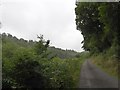
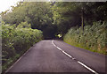
Minor road by the Woolleigh Brook
The stream is beside the field on the left, with Summerhill Wood on the right
Image: © David Smith
Taken: 14 Jul 2015
0.08 miles
2
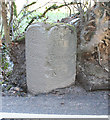
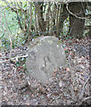
Old Milestone by the A3124, Castle Hill, Beaford Parish
Carved stone post by the A3124, in parish of BEAFORD (TORRIDGE District), Castle Hill, 400m East of Woolleigh Bridge, 500m North West of Woolleigh Barton, on the verge against bank, beside drain gully, opposite telegraph pole, on North side of road. Torrington wedge, erected by the Great Torrington turnpike trust in the 19th century.
Inscription reads:-
: 31 / Miles / EXON : : 3 / Miles / Torrington :
Carved benchmark on lower right face.
Grade II Listed. List Entry Number: 1326564
https://historicengland.org.uk/listing/the-list/list-entry/1326564
Milestone Society National ID: DV_GTEX03
Image: © Alan Rosevear
Taken: 2 Feb 2012
0.09 miles
3
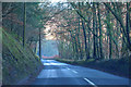
Beaford : The A3124
Heading through the parish of Beaford.
Image: © Lewis Clarke
Taken: 4 Dec 2019
0.12 miles
4
Beaford : The A3124
Heading through the parish of Beaford.
Image: © Lewis Clarke
Taken: 4 Dec 2019
0.12 miles
5
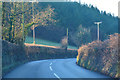
A3124 running through woods
Heading east.
Image: © J.Hannan-Briggs
Taken: 20 Jul 2017
0.13 miles
6
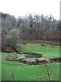
Meanders on the Woolleigh Brook
The tributary of the Torridge wiggles its way through a meadow between steep wooded valley sides; on the far side is Blinsham Wood.
Image: © Derek Harper
Taken: 4 Jan 2008
0.16 miles
7
Old Bridge Marker by the A3124, Castle Hill, Beaford parish
Bridge Marker by the A3124, in Beaford parish (Torridge District), Castle Hill, East of Woolleigh Bridge, in hedge by field gate, North side of road.
Surveyed
Milestone Society National ID: DV_GTEX02br
Image: © A Rosevear
Taken: 2 Feb 2012
0.23 miles
8
Woolleigh Brook valley
Geese patrol a meadow beside the meandering brook. From roughly the same spot as Image
Image: © Derek Harper
Taken: 4 Jan 2008
0.24 miles