IMAGES TAKEN NEAR TO
Warkleigh, UMBERLEIGH, EX37 9DG
Introduction
This page details the photographs taken nearby to EX37 9DG by members of the Geograph project.
The Geograph project started in 2005 with the aim of publishing, organising and preserving representative images for every square kilometre of Great Britain, Ireland and the Isle of Man.

There are currently over 7.5m images from over14,400 individuals and you can help contribute to the project by visiting https://www.geograph.org.uk
Image Map
Images are licensed for reuse under creativecommons.org/licenses/by-sa/2.0
Notes
- Clicking on the map will re-center to the selected point.
- The higher the marker number, the further away the image location is from the centre of the postcode.
Image Listing (9 Images Found)
Images are licensed for reuse under creativecommons.org/licenses/by-sa/2.0
Image
Details
Distance
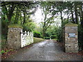
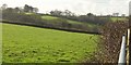
3

Gatepiers, Warkleigh
At Warkleigh Cross, and at the entrance to the Old Rectory.
Image: © Derek Harper
Taken: 8 Feb 2017
0.11 miles
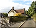
6
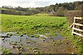
Field near Warkleigh
From the lane from Satterleigh, a view up that valley that the eastern part of the village occupies. On the right, on this side of Warkleigh Cottage, is The Nook https://www.historicengland.org.uk/listing/the-list/list-entry/1273371 .
Image: © Derek Harper
Taken: 8 Feb 2017
0.17 miles
7
Fields at Warkleigh
Rather into the sun and consequently not very clear, this is the view from across the lane from Image
Image: © Derek Harper
Taken: 8 Feb 2017
0.21 miles
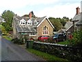
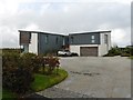
8
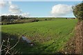
Field, Warkleigh
On the left is Higher Beers Farm with a listed farmhouse https://www.historicengland.org.uk/listing/the-list/list-entry/1258618 . On the extreme right is a bungalow at Hilltown, in Image
Image: © Derek Harper
Taken: 8 Feb 2017
0.21 miles
9
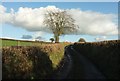
Lane to Satterleigh
From the same spot as Image, looking up the lane from Warkleigh.
Image: © Derek Harper
Taken: 8 Feb 2017
0.25 miles