IMAGES TAKEN NEAR TO
High Bickington, UMBERLEIGH, EX37 9BE
Introduction
This page details the photographs taken nearby to EX37 9BE by members of the Geograph project.
The Geograph project started in 2005 with the aim of publishing, organising and preserving representative images for every square kilometre of Great Britain, Ireland and the Isle of Man.

There are currently over 7.5m images from over14,400 individuals and you can help contribute to the project by visiting https://www.geograph.org.uk
Image Map
Images are licensed for reuse under creativecommons.org/licenses/by-sa/2.0
Notes
- Clicking on the map will re-center to the selected point.
- The higher the marker number, the further away the image location is from the centre of the postcode.
Image Listing (11 Images Found)
Images are licensed for reuse under creativecommons.org/licenses/by-sa/2.0
Image
Details
Distance
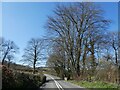
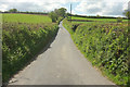
2
A377 at Broadwood
With a (private) track forking off to the left to Lower Broadwood and Broadwood.
Image: © Derek Harper
Taken: 4 May 2019
0.07 miles
3
Grass field by A377 #1
Looking over the roadside hedge on the right of Image On the far slopes of the Taw valley is Brightley Wood.
Image: © Derek Harper
Taken: 4 May 2019
0.07 miles
4
Grass field by the A377 #2
Looking more to the right than Image], again with Brightley Wood in the background.
Image: © Derek Harper
Taken: 4 May 2019
0.11 miles
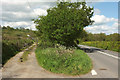
5
Lane to Northwood
A no through road that leaves the A377 from where Image] was taken, climbing between banks.
Image: © Derek Harper
Taken: 4 May 2019
0.12 miles
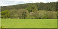
6
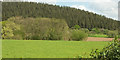
Grass field by the A377 #3
Looking more to the right than Image], with fields either side of the River Taw visible on the right of the small flood plain wood. Again, Brightley Wood dominates the background.
Image: © Derek Harper
Taken: 4 May 2019
0.14 miles
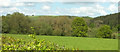
7
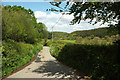
Pound Lane
A lane descending from High Bickington reaches the last stretch before meeting the A377. The building visible across the valley floor is the old millhouse as Brightley.
Image: © Derek Harper
Taken: 4 May 2019
0.15 miles
8

North Devon : Pound Lane
Looking along Pound Lane.
Image: © Lewis Clarke
Taken: 5 May 2019
0.16 miles
9
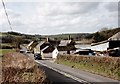
Weirmarsh Farm
Weirmarsh Farm on a sunny February afternoon. The Farmyard lies between the A377 and the River Taw.
Image: © David Brinicombe
Taken: 21 Feb 2007
0.21 miles
10
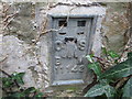
Ordnance Survey Flush Bracket 11142
This can be found on the wall of a building at Weirmarsh Farm.
For more detail see : http://www.bench-marks.org.uk/bm22464
Image: © Peter Wood
Taken: 29 Mar 2015
0.23 miles