IMAGES TAKEN NEAR TO
East Street, SOUTH MOLTON, EX36 3HT
Introduction
This page details the photographs taken nearby to East Street, EX36 3HT by members of the Geograph project.
The Geograph project started in 2005 with the aim of publishing, organising and preserving representative images for every square kilometre of Great Britain, Ireland and the Isle of Man.

There are currently over 7.5m images from over14,400 individuals and you can help contribute to the project by visiting https://www.geograph.org.uk
Image Map
Images are licensed for reuse under creativecommons.org/licenses/by-sa/2.0
Notes
- Clicking on the map will re-center to the selected point.
- The higher the marker number, the further away the image location is from the centre of the postcode.
Image Listing (75 Images Found)
Images are licensed for reuse under creativecommons.org/licenses/by-sa/2.0
Image
Details
Distance
1
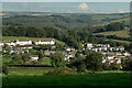
Higher East Street near Jubilee Gardens and Broad Close
Across the moor and over the horizon is Simonsbath.
Image: © Roger A Smith
Taken: 10 Oct 2021
0.02 miles
2
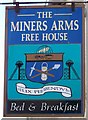
Sign for the Miners Arms, North Molton
Image: © Maigheach-gheal
Taken: 12 Mar 2008
0.03 miles

4
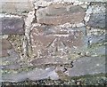
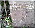
Ordnance Survey Cut Mark
This OS cut mark can be found on the outbuilding at Holdridge, East Street. It marks a point 185.556m above mean sea level.
Image: © Adrian Dust
Taken: 22 Nov 2018
0.03 miles
5

The Miners Arms, North Molton
Over the centuries both copper and iron have been mined around the village. A story told in the pub by people seeking the reason for the chimney smoke beating back into the bar a few years ago discovered a board embedded in the cob-and-stone-built chimney bearing the names of six masons and carpenters who restored the inn in 1897. A Victorian halfpenny was embedded in the board.
Image: © Maigheach-gheal
Taken: 12 Mar 2008
0.03 miles
6
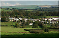
Houses on Higher East Street and Jubilee Gardens
Beyond the horizon towards the coast is the village of Brendon.
Image: © Roger A Smith
Taken: 10 Oct 2021
0.05 miles
7
Ordnance Survey Cut Mark
This mostly destroyed OS cut mark can be found on the gatepost of Frayne House. It marks a point 168.046m above mean sea level.
Image: © Adrian Dust
Taken: 22 Nov 2018
0.06 miles
8
Street Scene, North Molton
North Molton is a large village straddling the Exmoor National Park boundary. The place name means the northern settlement on the River Mole. Mole comes from the Celtic moel, meaning a bare, rounded hill.
Image: © Maigheach-gheal
Taken: 12 Mar 2008
0.08 miles

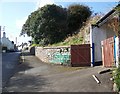
10

North Molton: Colourful Gardens in East Street
Image: © Mr Eugene Birchall
Taken: 16 Jul 2014
0.09 miles