IMAGES TAKEN NEAR TO
Barbrook, LYNTON, EX35 6PF
Introduction
This page details the photographs taken nearby to EX35 6PF by members of the Geograph project.
The Geograph project started in 2005 with the aim of publishing, organising and preserving representative images for every square kilometre of Great Britain, Ireland and the Isle of Man.

There are currently over 7.5m images from over14,400 individuals and you can help contribute to the project by visiting https://www.geograph.org.uk
Image Map
Images are licensed for reuse under creativecommons.org/licenses/by-sa/2.0
Notes
- Clicking on the map will re-center to the selected point.
- The higher the marker number, the further away the image location is from the centre of the postcode.
Image Listing (29 Images Found)
Images are licensed for reuse under creativecommons.org/licenses/by-sa/2.0
Image
Details
Distance
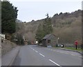
1
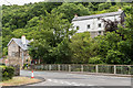
Home Cottage and the Old Sawmills
Buildings in Barbrook, overlooking the West Lyn River. Home Cottage is on the left of the photo and the Old Sawmills is on the right. The latter dates from the late 18th/early 19th Century and is grade II listed - see www.historicengland.org.uk/listing/the-list/list-entry/1210222.
Image: © Ian Capper
Taken: 17 Jun 2018
0.02 miles
2
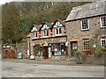
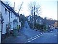
Barbrook Post Office
Barbrook is a pretty little village on the West Lyn River.
Image: © Grant Sherman
Taken: 29 Jan 2005
0.02 miles
4
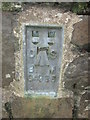
Ordnance Survey Flush Bracket (G4925)
This OS Flush Bracket can be found on the north parapet, north face of the bridge. It marks a point 186.576m above mean sea level.
Image: © Adrian Dust
Taken: 19 Oct 2015
0.02 miles
6
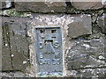
Ordnance Survey Flush Bracket G4925
This can be found on the parapet of a bridge at Barbrook.
For more detail see : http://www.bench-marks.org.uk/bm16199
Image: © Peter Wood
Taken: 13 Oct 2013
0.03 miles
7
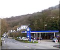
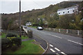
Gulf filling station, on A39 in Barbrook
Image: © David Smith
Taken: 16 Feb 2018
0.03 miles
8
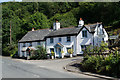
Cottages in Barbrook
Situated at the bottom of Stock Hill and facing the A39.
Image: © Bill Boaden
Taken: 5 Jul 2017
0.04 miles
10
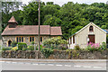
St Bartholomew's Church, Barbrook
Church built in 1875. To its right is Barbrook Village Hall, housed in a "tin tabernacle", built around 1900, firstly as a reading room, then a church hall before finally seeing its current use, run by a separate trust, from 2002.
Image: © Ian Capper
Taken: 17 Jun 2018
0.05 miles