IMAGES TAKEN NEAR TO
Cherrybridge, LYNTON, EX35 6PE
Introduction
This page details the photographs taken nearby to Cherrybridge, EX35 6PE by members of the Geograph project.
The Geograph project started in 2005 with the aim of publishing, organising and preserving representative images for every square kilometre of Great Britain, Ireland and the Isle of Man.

There are currently over 7.5m images from over14,400 individuals and you can help contribute to the project by visiting https://www.geograph.org.uk
Image Map
Images are licensed for reuse under creativecommons.org/licenses/by-sa/2.0
Notes
- Clicking on the map will re-center to the selected point.
- The higher the marker number, the further away the image location is from the centre of the postcode.
Image Listing (29 Images Found)
Images are licensed for reuse under creativecommons.org/licenses/by-sa/2.0
Image
Details
Distance
1
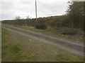
Lynton and Barnstaple Railway ? Site of Bridge 79
The site of Bridge 79, which has long been demolished. The trackbed of the railway ran from directly under the photographer’s feet, and on to the right of the telegraph pole as it descended towards Lynton Station. Study of the 1904 map of the route shows the bridge at roughly this level, going over the path which would then have been several feet lower.
The Lynton & Barnstaple Railway was a 19 mile long narrow gauge railway, which ran across the stunning Exmoor landscape, from 1898, until its closure in 1935. In 2004, after many years of hard work and negotiation, a small section was re-opened. It is hoped that this section will soon be a working part of the railway once more. One of the world’s most famous little railways, you can read more of the exciting plans for the coming years at www.lynton-rail.co.uk
Image: © Barrie Cann
Taken: 25 Oct 2018
0.06 miles

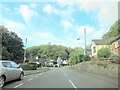
3

Gulf filling station in Barbrook, by A39
Image: © David Smith
Taken: 23 Feb 2020
0.07 miles
4

Ordnance Survey Cut Mark
This OS cut mark can be found on the SE face of St Bartholomew's Church. It marks a point 188.656m above mean sea level.
Image: © Adrian Dust
Taken: 6 Sep 2015
0.08 miles
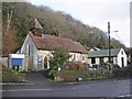
6
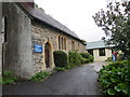
St Bartholomew Church, Barbrook
A small church on the A39 at Barbrook.
Image: © Guy Wareham
Taken: 10 Oct 2008
0.08 miles
7
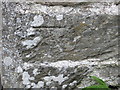
Ordnance Survey Cut Mark
This mark can be found on the wall of St Bartholomew's Church at Barbrook.
For more detail see : http://www.bench-marks.org.uk/bm52419
Image: © Peter Wood
Taken: 13 Oct 2013
0.08 miles
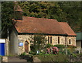
8
The church of St Bartholomew at Barbrook
Image: © Peter Wood
Taken: 13 Oct 2013
0.08 miles
10
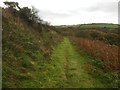
Lynton and Barnstaple Railway - Disused trackbed at Dean Steep
The site of the former trackbed east of milepost 18, at Dean Steep, on the final approach to Lynton Station. The line here ran on a narrow ledge, high above the valley floor which falls away to the right of this photo
The Lynton & Barnstaple Railway was a 19 mile long narrow gauge railway, which ran across the stunning Exmoor landscape, from 1898, until its closure in 1935. In 2004, after many years of hard work and negotiation, a small section was re-opened. It is hoped that this section will soon be a working part of the railway once more. One of the world’s most famous little railways, you can read more of the exciting plans for the coming years at www.lynton-rail.co.uk
Image: © Barrie Cann
Taken: 25 Oct 2018
0.08 miles