IMAGES TAKEN NEAR TO
LYNTON, EX35 6BB
Introduction
This page details the photographs taken nearby to EX35 6BB by members of the Geograph project.
The Geograph project started in 2005 with the aim of publishing, organising and preserving representative images for every square kilometre of Great Britain, Ireland and the Isle of Man.

There are currently over 7.5m images from over14,400 individuals and you can help contribute to the project by visiting https://www.geograph.org.uk
Image Map
Images are licensed for reuse under creativecommons.org/licenses/by-sa/2.0
Notes
- Clicking on the map will re-center to the selected point.
- The higher the marker number, the further away the image location is from the centre of the postcode.
Image Listing (19 Images Found)
Images are licensed for reuse under creativecommons.org/licenses/by-sa/2.0
Image
Details
Distance
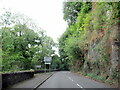
1
The Olde Cottage Inne, Lynmouth
Also a Thai restaurant Image
Image: © David Smith
Taken: 16 Feb 2018
0.04 miles
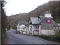
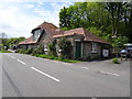
2
The Cottage Inn, Lynbridge
The home of Fat Belly beers, and it also accommodates a Thai restaurant.
Image: © Bill Boaden
Taken: 2 Jul 2017
0.04 miles
3
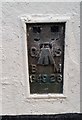
Ordnance Survey Flush Bracket (G4926)
This OS Flush Bracket can be found on the NW face of the Public House. It marks a point 134.041m above mean sea level.
Image: © Adrian Dust
Taken: 23 Nov 2018
0.04 miles
4
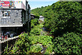
West Lyn River at Lynbridge
Looking downstream from Lyn Bridge. The Cottage Inn is on the left.
Image: © Bill Boaden
Taken: 2 Jul 2017
0.05 miles
6
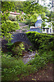
Lyn Bridge
Footbridge over the West Lyn River at Lynbridge. Bridge Inn is to the right.
Image: © Roger Gittins
Taken: 21 May 2007
0.06 miles
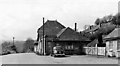
7
Former Lynton & Lynmouth terminus of Lynton & Barnstaple Railway, 1991
View northward towards the village: ex-Lynton & Barnstaple 1'11½" line, closed 29/9/35. This house is little changed since my shot 31 years earlier Image], cf. also Image
Image: © Ben Brooksbank
Taken: 13 Jun 1991
0.06 miles
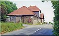
8
Lynton & Lynmouth Station (converted)
View SW, towards Barnstaple. The ex-Southern Railway Lynton & Barnstaple narrow-gauge line had been closed completely on 29/9/35 and when photographed in 1960 this station (some way short of Lynton) was a private house. The Lynton & Barnstaple Railway Association/Company acquired Woody Bay Station in 2000 and by 2006 had restored a mile of the line from there to Killington Lane, with plans to return to Lynton eventually.
Image: © Ben Brooksbank
Taken: 25 Apr 1960
0.07 miles
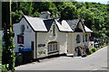
9
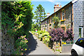
Cottages at Lynbridge
The terrace is on the path to Lynton, with narrow vehicle access available only from this end.
Image: © Bill Boaden
Taken: 2 Jul 2017
0.07 miles
10
Lynton & Lynmouth railway station (site), Devon
Opened in 1898 by the Lynton & Barnstaple Railway, later part of the Southern Railway, on their narrow gauge (1 foot 11 1⁄2 inch) line, this station closed in 1935 and was dismantled
View south west at the forecourt from a similar position to Image taken some 59 years previously.
Image: © Nigel Thompson
Taken: 18 May 2019
0.11 miles