IMAGES TAKEN NEAR TO
EX34 8PB
Introduction
This page details the photographs taken nearby to EX34 8PB by members of the Geograph project.
The Geograph project started in 2005 with the aim of publishing, organising and preserving representative images for every square kilometre of Great Britain, Ireland and the Isle of Man.

There are currently over 7.5m images from over14,400 individuals and you can help contribute to the project by visiting https://www.geograph.org.uk
Image Map
Images are licensed for reuse under creativecommons.org/licenses/by-sa/2.0
Notes
- Clicking on the map will re-center to the selected point.
- The higher the marker number, the further away the image location is from the centre of the postcode.
Image Listing (73 Images Found)
Images are licensed for reuse under creativecommons.org/licenses/by-sa/2.0
Image
Details
Distance
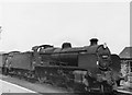
2
Ilfracombe station approaches, 1969
The track from Barnstaple had been singled by 1969, but the layout at Ilfracombe seems fairly complete, although something has gone on the left. All is swept away and built on now. After a very interesting ride in a DMU over the severe gradients from Barnstaple.
Image: © Robin Webster
Taken: Unknown
0.06 miles
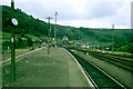
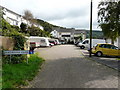
4
Factory at Ilfracombe old station
This unprepossessing and security-conscious factory occupies the site of the old railway station at Ilfracombe. The station was situated high above the main part of the town and there was a sharp drop beyond the buffer stops. Fortunately, despite the line approaching the station on a steep gradient, no trains ever failed to stop before the drop.
Image: © Ron Strutt
Taken: 1 Sep 2003
0.08 miles
5
The section of Slade Valley Road that heads in a northerly direction.
Image: © Roger A Smith
Taken: 7 Sep 2008
0.10 miles
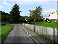
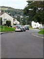
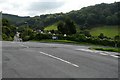
6
Slade Valley Road at the junction with Burnside Road.
Image: © Roger A Smith
Taken: 7 Sep 2008
0.10 miles
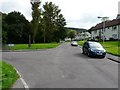
9
Slade Road at the junction with Hillington.
Image: © Roger A Smith
Taken: 7 Sep 2008
0.11 miles
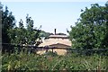
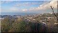
10
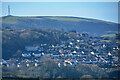
Ilfracombe : Town Suburbs
Looking across to the suburbs of Ilfracombe.
Image: © Lewis Clarke
Taken: 27 Feb 2021
0.12 miles