IMAGES TAKEN NEAR TO
St. Brannocks Road, ILFRACOMBE, EX34 8EP
Introduction
This page details the photographs taken nearby to St. Brannocks Road, EX34 8EP by members of the Geograph project.
The Geograph project started in 2005 with the aim of publishing, organising and preserving representative images for every square kilometre of Great Britain, Ireland and the Isle of Man.

There are currently over 7.5m images from over14,400 individuals and you can help contribute to the project by visiting https://www.geograph.org.uk
Image Map (Loading...)


Getting Data...Please wait
Leaflet Map data © OpenStreetMap
Images are licensed for reuse under creativecommons.org/licenses/by-sa/2.0
Notes
- Clicking on the map will re-center to the selected point.
- The higher the marker number, the further away the image location is from the centre of the postcode.
Image Listing (48 Images Found)
Images are licensed for reuse under creativecommons.org/licenses/by-sa/2.0
Image
Details
Distance
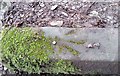
2
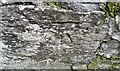
Ordnance Survey Cut Mark
This OS cut mark can be found on the wall at the road junction. It marks a point 47.390m above mean sea level.
Image: © Adrian Dust
Taken: 16 Feb 2017
0.05 miles

4
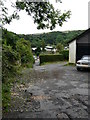
Unmarked footpath which connects two halves of Kingsley Avenue.
Image: © Roger A Smith
Taken: 29 Aug 2008
0.08 miles
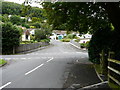
5
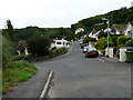
Bicclescombe Park Road heading towards Score Valley with Kingsley Avenue off to the left.
Image: © Roger A Smith
Taken: 29 Aug 2008
0.08 miles
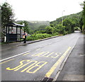
7
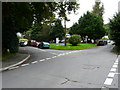
The junction of Bicclescombe Park Road with Kingsley Avenue and Parkway.
Image: © Roger A Smith
Taken: 29 Aug 2008
0.09 miles
8
Ordnance Survey Rivet
This OS rivet can be found on the stone step SE side of the path. It marks a point 102.550m above mean sea level.
Image: © Adrian Dust
Taken: 16 Feb 2017
0.09 miles
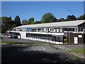
9
St Brannock's Road bus stop and shelter, Ilfracombe
Viewed across the A361 St Brannock's Road from the corner of Kingsley Avenue.
Image: © Jaggery
Taken: 25 Jun 2017
0.09 miles
10

King George VI postbox on a suburban corner of Ilfracombe
In June 2017 ivy is encroaching on the postbox in the wall on the corner of St Brannock's Road and Kingsley Avenue.
Image: © Jaggery
Taken: 25 Jun 2017
0.10 miles