IMAGES TAKEN NEAR TO
Heddon Mill, BRAUNTON, EX33 2NF
Introduction
This page details the photographs taken nearby to EX33 2NF by members of the Geograph project.
The Geograph project started in 2005 with the aim of publishing, organising and preserving representative images for every square kilometre of Great Britain, Ireland and the Isle of Man.

There are currently over 7.5m images from over14,400 individuals and you can help contribute to the project by visiting https://www.geograph.org.uk
Image Map
Images are licensed for reuse under creativecommons.org/licenses/by-sa/2.0
Notes
- Clicking on the map will re-center to the selected point.
- The higher the marker number, the further away the image location is from the centre of the postcode.
Image Listing (32 Images Found)
Images are licensed for reuse under creativecommons.org/licenses/by-sa/2.0
Image
Details
Distance
1
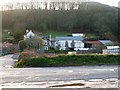
Heddon Mills between Knowle & Ilfracombe
Image: © Roger A Smith
Taken: 4 Apr 2006
0.01 miles
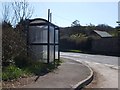
2

Old level crossing by the A361
Lane from North Buckland at the old level crossing by the A361
Image: © Shaun Ferguson
Taken: 6 Jul 2011
0.02 miles

5

Knowle : A361
A tractor pulls out onto the road.
Image: © Lewis Clarke
Taken: 4 Jun 2021
0.03 miles
6

Knowle : A361
Looking along the A361 near Heddon Mills.
Image: © Lewis Clarke
Taken: 4 Jun 2021
0.04 miles


9
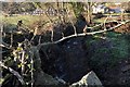
The view downstream from an unnamed bridge near Heddon Mills on the river Caen
Image: © Roger A Smith
Taken: 14 Dec 2010
0.09 miles
10
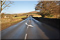
The A361 near Heddon Mills where the river Caen passes underneath
Image: © Roger A Smith
Taken: 14 Dec 2010
0.09 miles