IMAGES TAKEN NEAR TO
Victoria Street, BARNSTAPLE, EX32 9HT
Introduction
This page details the photographs taken nearby to Victoria Street, EX32 9HT by members of the Geograph project.
The Geograph project started in 2005 with the aim of publishing, organising and preserving representative images for every square kilometre of Great Britain, Ireland and the Isle of Man.

There are currently over 7.5m images from over14,400 individuals and you can help contribute to the project by visiting https://www.geograph.org.uk
Image Map
Images are licensed for reuse under creativecommons.org/licenses/by-sa/2.0
Notes
- Clicking on the map will re-center to the selected point.
- The higher the marker number, the further away the image location is from the centre of the postcode.
Image Listing (167 Images Found)
Images are licensed for reuse under creativecommons.org/licenses/by-sa/2.0
Image
Details
Distance
1

Grosvenor Church, Barnstaple.
Formerly the railway goods shed at the Great Western Railway, Victoria Road station yard, Barnstaple. This was the terminus of the Taunton to Barnstaple Railway which closed in the 1960s. The building is now used as a church and community meeting hall. Behind the wall on the left were the railway cattle pens.
Image: © Maurice Clements
Taken: 26 Oct 2006
0.03 miles
2
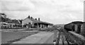
Barnstaple (Victoria Road) Station
View eastward, towards Taunton, from buffer-stops of disused terminus of former GWR line from Taunton, which also connected with the SR line at Barnstaple Junction until the line was closed entirely on 3/10/66. Meanwhile this station had been closed to passengers on 13/6/60 but to Goods (from Barnstaple Junction) not until 5/3/70.
Image: © Ben Brooksbank
Taken: 17 Apr 1964
0.06 miles
3

Looking downstream on Coney Gut from a bridge on Victoria Street
Image: © Roger A Smith
Taken: 7 Jan 2012
0.06 miles
4
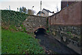
A bridge on Victoria Street as seen downstream on Coney Gut
Image: © Roger A Smith
Taken: 7 Jan 2012
0.06 miles
5
A bridge on Victoria Street under which passes Coney Gut
Image: © Roger A Smith
Taken: 7 Jan 2012
0.06 miles
6
Where Victoria Street passes over Coney Gut
Image: © Roger A Smith
Taken: 7 Jan 2012
0.06 miles
7
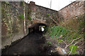
Looking downstream on Coney Gut towards a bridge on Victoria Street
Image: © Roger A Smith
Taken: 7 Jan 2012
0.06 miles
8
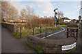
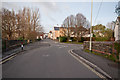
Portmarsh Field between Portmarsh Lane and Gloster Road
Portmarsh Field is a flood storage area for Coney Gut.
Image: © Roger A Smith
Taken: 7 Jan 2012
0.06 miles
9

Portmarsh Field between Gloster Road and Portmarsh Lane
Portmarsh field is a flood storage area for Coney Gut.
Image: © Roger A Smith
Taken: 7 Jan 2012
0.06 miles
10

The southern side of Grosvenor Church formerly a railway building
Image: © Roger A Smith
Taken: 16 Jun 2016
0.06 miles