IMAGES TAKEN NEAR TO
St. Johns Close, BARNSTAPLE, EX32 9AZ
Introduction
This page details the photographs taken nearby to St. Johns Close, EX32 9AZ by members of the Geograph project.
The Geograph project started in 2005 with the aim of publishing, organising and preserving representative images for every square kilometre of Great Britain, Ireland and the Isle of Man.

There are currently over 7.5m images from over14,400 individuals and you can help contribute to the project by visiting https://www.geograph.org.uk
Image Map (Loading...)


Getting Data...Please wait
Leaflet Map data © OpenStreetMap
Images are licensed for reuse under creativecommons.org/licenses/by-sa/2.0
Notes
- Clicking on the map will re-center to the selected point.
- The higher the marker number, the further away the image location is from the centre of the postcode.
Image Listing (68 Images Found)
Images are licensed for reuse under creativecommons.org/licenses/by-sa/2.0
Image
Details
Distance
1
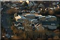
The Lampard Community School, St John's road, Newport, Barnstaple
Image: © Roger A Smith
Taken: 16 Feb 2016
0.05 miles
2
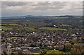
The Lampard Community School, St Johns Lane, Barnstaple
The school and St Johns lane can be seen to the left of the image. The mast at Huntshaw Cross is on the horizon.
Image: © Roger A Smith
Taken: 27 Apr 2012
0.05 miles
3

Barnstaple : Lampard Community School
A school on St John's Lane.
Image: © Lewis Clarke
Taken: 21 Apr 2021
0.07 miles
4

Barnstaple : Lampard Community School
A school on St John's Lane.
Image: © Lewis Clarke
Taken: 21 Apr 2021
0.07 miles
5
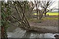
Coney Gut passing by a playing field near Rose Lane
Image: © Roger A Smith
Taken: 7 Jan 2012
0.07 miles
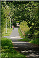
6
Looking upstream on Coney Gut from a cycle path near Rose Lane
Image: © Roger A Smith
Taken: 7 Jan 2012
0.08 miles
7
A cycle path near Rose Lane as seen from downstream on Coney Gut
Image: © Roger A Smith
Taken: 7 Jan 2012
0.08 miles
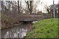
8
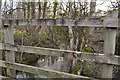
A footbridge over Coney Gut near Rose Lane
Image: © Roger A Smith
Taken: 7 Jan 2012
0.08 miles
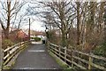
9
A footpath over Coney Gut near Rose Lane
Image: © Roger A Smith
Taken: 7 Jan 2012
0.08 miles
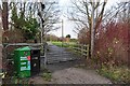
10
The eastbound route of the old GWR line, now a cycle path
This route left Barnstaple along what is now the A361.
Image: © Roger A Smith
Taken: 18 Aug 2014
0.08 miles