IMAGES TAKEN NEAR TO
EX32 8SA
Introduction
This page details the photographs taken nearby to EX32 8SA by members of the Geograph project.
The Geograph project started in 2005 with the aim of publishing, organising and preserving representative images for every square kilometre of Great Britain, Ireland and the Isle of Man.

There are currently over 7.5m images from over14,400 individuals and you can help contribute to the project by visiting https://www.geograph.org.uk
Image Map
Images are licensed for reuse under creativecommons.org/licenses/by-sa/2.0
Notes
- Clicking on the map will re-center to the selected point.
- The higher the marker number, the further away the image location is from the centre of the postcode.
Image Listing (505 Images Found)
Images are licensed for reuse under creativecommons.org/licenses/by-sa/2.0
Image
Details
Distance
1
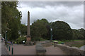
Park entrance and obelisk on the bank of the River Taw
The obelisk was erected to mark the opening of the park.
Image: © David Martin
Taken: 16 Sep 2018
0.01 miles
2
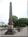
Rock obelisk
The area close to the Taw banks and the old town centre used to contain ruined cottages, a factory yard and a limekiln in the late nineteenth century. Local man William Rock became a wealthy printer and author and purchased the land for public benefit. Cleared of the past and landscaped, Rock Park was officially opened on 12th August, 1879; this obelisk marks the occasion and the northwest entrance. It bears an inscription: 'It is hoped the public will protect what is intended for public enjoyment'.
Image: © Neil Owen
Taken: 9 Jun 2023
0.01 miles
3
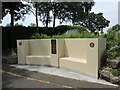
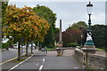
Rotary seating
Close to the war memorial is a relatively new stone seat. It was built to mark the centenary of the Rotary Club in 2005; designed by Brian Watts and supported by individual and group fund-raising.
Image: © Neil Owen
Taken: 9 Jun 2023
0.02 miles
4
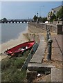
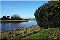
By the Taw
A slipway runs down to the River Taw beside Taw Vale. The reach of the Taw on the left is Westacott Pit. Downstream is Long Bridge.
Image: © Derek Harper
Taken: 18 Jul 2013
0.02 miles
5
A slipway into the River Taw by Rock Park
See also: Image
Image: © Roger A Smith
Taken: 19 Sep 2014
0.02 miles
6

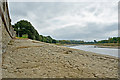
Taw Vale where it meets the other end of Litchdon street
Image: © Roger A Smith
Taken: 2 Nov 2016
0.02 miles
7
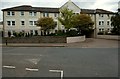
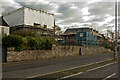
Barum Court, Litchdon Street, Barnstaple
The site of the town's Infirmary.
Barum is an alternative name for Barnstaple and is believed to originate from Roman times.
Image: © Roger A Smith
Taken: 24 Aug 2011
0.03 miles