IMAGES TAKEN NEAR TO
Foxglove Close, BARNSTAPLE, EX32 8RE
Introduction
This page details the photographs taken nearby to Foxglove Close, EX32 8RE by members of the Geograph project.
The Geograph project started in 2005 with the aim of publishing, organising and preserving representative images for every square kilometre of Great Britain, Ireland and the Isle of Man.

There are currently over 7.5m images from over14,400 individuals and you can help contribute to the project by visiting https://www.geograph.org.uk
Image Map
Images are licensed for reuse under creativecommons.org/licenses/by-sa/2.0
Notes
- Clicking on the map will re-center to the selected point.
- The higher the marker number, the further away the image location is from the centre of the postcode.
Image Listing (47 Images Found)
Images are licensed for reuse under creativecommons.org/licenses/by-sa/2.0
Image
Details
Distance
1
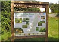
Information Board Whiddon Valley Woods Barnstaple
At the north end of the footpath past Whiddon Valley Woods, South West Forest have erected this information board, illustrating the diversity of flora and fauna, found just yards from a housing estate. The full detail of this board can be found on the South West Forest web-site
www.southwestforest.org.uk/community-woodland/pdfs/Whiddon-Valley.pdf
Image: © Barrie Cann
Taken: 11 Sep 2009
0.05 miles
2
The view downstream from a bridge on Coney Gut near Primrose Avenue
Image: © Roger A Smith
Taken: 12 Jan 2012
0.07 miles
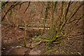
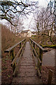
3
A footbridge on Coney Gut near Primrose Avenue as seen from upstream
Image: © Roger A Smith
Taken: 12 Jan 2012
0.07 miles
4
A footbridge on Coney Gut near Primrose Avenue as seen from downstream
Image: © Roger A Smith
Taken: 12 Jan 2012
0.07 miles
5
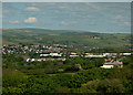
A view across the east of Barnstaple
The centre of this image is at Westacott. Coombe Farm is to the right of centre. The roofs of the Roundswell Business Park are visible just below centre. In the distance are hills around Simonsbath.
Image: © Roger A Smith
Taken: 2 May 2020
0.07 miles
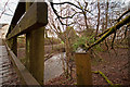
6
A bridge over Coney Gut near Primrose Avenue
Image: © Roger A Smith
Taken: 12 Jan 2012
0.08 miles
7
The view upstream from a footbridge on Coney Gut near Primrose Avenue
Image: © Roger A Smith
Taken: 12 Jan 2012
0.08 miles
8
A bridge over Coney Gut near Primrose Avenue
Image: © Roger A Smith
Taken: 12 Jan 2012
0.08 miles
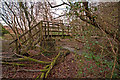
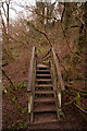
9
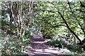
Footpath through Whiddon Valley Woods, Barnstaple
Footpath through Whiddon Valley Woods, on the eastern edge of Barnstaple. Early morning walks with the dog are frequently accompanied by the squirrels running through the trees, and if the dog is lucky, across the path in front of us!
The wood is owned by Devon County Council, and was formerly known as Maidenford Woods until 1990. The area is well-maintained, with frequent coppicing, and community projects to maintain interest and keep it clean and in good condition
For further information, see the South West Forest web-site at
http://www.southwestforest.org.uk/community-woodland/#whiddon-valley
Image: © Barrie Cann
Taken: 11 Sep 2009
0.08 miles
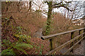
10
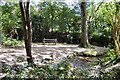
Whiddon Valley Woods, Barnstaple
A small clearing in the woods, where you can watch the squirrels running through the trees. The stream is called Coney Gut and runs the whole length of this woodland. The wood is owned by Devon County Council, and was formerly known as Maidenford Woods until 1990. Just a few yards beyond the trees in the background, is a whole housing estate.
For further information, see the South West Forest web-site at
www.southwestforest.org.uk/community-woodland/pdfs/Whiddon-Valley.pdf
Image: © Barrie Cann
Taken: 11 Sep 2009
0.09 miles