IMAGES TAKEN NEAR TO
Appletree Close, BARNSTAPLE, EX32 8PN
Introduction
This page details the photographs taken nearby to Appletree Close, EX32 8PN by members of the Geograph project.
The Geograph project started in 2005 with the aim of publishing, organising and preserving representative images for every square kilometre of Great Britain, Ireland and the Isle of Man.

There are currently over 7.5m images from over14,400 individuals and you can help contribute to the project by visiting https://www.geograph.org.uk
Image Map
Images are licensed for reuse under creativecommons.org/licenses/by-sa/2.0
Notes
- Clicking on the map will re-center to the selected point.
- The higher the marker number, the further away the image location is from the centre of the postcode.
Image Listing (30 Images Found)
Images are licensed for reuse under creativecommons.org/licenses/by-sa/2.0
Image
Details
Distance
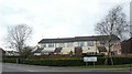
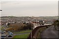
2
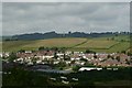
Whiddon Valley estate with the mast on Maidenford Hill in the background.
Image: © Roger A Smith
Taken: 20 Jun 2009
0.10 miles
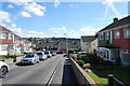

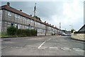
6
Modern terrace of houses near Barton Road, Barnstaple
The houses front onto a side road, Lower Moor
Image: © David Smith
Taken: 22 Mar 2019
0.16 miles
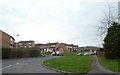
8
Barnstaple estate
Forches housing estates in Barnstaple.
Image: © Fiona Avis
Taken: Unknown
0.19 miles
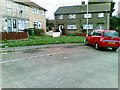
9
Barton Road on Whiddon Valley estate, Barnstaple
Image: © David Smith
Taken: 22 Mar 2019
0.19 miles
10
The Mast near Maidenford as seen from High Wall
High Wall occupies the lower right corner of the image. Sticklepath Hill is on the left.
Image: © Roger A Smith
Taken: 23 Nov 2011
0.22 miles