IMAGES TAKEN NEAR TO
West Close, BARNSTAPLE, EX32 0ST
Introduction
This page details the photographs taken nearby to West Close, EX32 0ST by members of the Geograph project.
The Geograph project started in 2005 with the aim of publishing, organising and preserving representative images for every square kilometre of Great Britain, Ireland and the Isle of Man.

There are currently over 7.5m images from over14,400 individuals and you can help contribute to the project by visiting https://www.geograph.org.uk
Image Map (Loading...)


Getting Data...Please wait
Leaflet Map data © OpenStreetMap
Images are licensed for reuse under creativecommons.org/licenses/by-sa/2.0
Notes
- Clicking on the map will re-center to the selected point.
- The higher the marker number, the further away the image location is from the centre of the postcode.
Image Listing (10 Images Found)
Images are licensed for reuse under creativecommons.org/licenses/by-sa/2.0
Image
Details
Distance


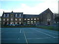
3
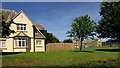
West Buckland School
In the foreground is The Gables, part of the boarding accommodation. On the right is the listed building at the core of the school, "1860-1 by R D Gould" https://historicengland.org.uk/listing/the-list/list-entry/1107568 . "The school was founded in 1858 at South Stoodleigh by J L Brereton". Seen from the lane carrying the Tarka Trail and the Macmillan Way West.
Image: © Derek Harper
Taken: 22 Jun 2019
0.05 miles
4
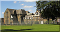
West Buckland School
A detail of Image] from the same spot. Some of the details listed at https://historicengland.org.uk/listing/the-list/list-entry/1107568 can be spotted.
Image: © Derek Harper
Taken: 22 Jun 2019
0.07 miles

6
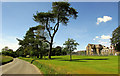
West Buckland School
The school building is listed: "1860-1 by R D Gould, enlarged to rear 1863 and 1871, range to west completed 1876" https://historicengland.org.uk/listing/the-list/list-entry/1107568 . See also Image The lane on the left carries the Tarka Trail and the Macmillan Way West.
Image: © Derek Harper
Taken: 22 Jun 2019
0.09 miles
7
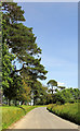
Lane past West Buckland School
Looking right from Image The lane carries both the Tarka Trail and the Macmillan Way West.
Image: © Derek Harper
Taken: 22 Jun 2019
0.10 miles
8
West Buckland School
The main School buildings, on left and in centre date from 4 October 1860 when Earl Fortsecue (from nearby Castle Hill House https://www.geograph.org.uk/photo/3364399 Image) laid the foundation stone.
Image: © Op Deo
Taken: 4 Dec 2003
0.10 miles
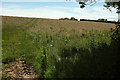
9

Field opposite West Buckland School
Looking left from Image
Image: © Derek Harper
Taken: 22 Jun 2019
0.11 miles
10
Field opposite West Buckland School
Image: © Derek Harper
Taken: 22 Jun 2019
0.14 miles