IMAGES TAKEN NEAR TO
Russell Close, BARNSTAPLE, EX32 0NZ
Introduction
This page details the photographs taken nearby to Russell Close, EX32 0NZ by members of the Geograph project.
The Geograph project started in 2005 with the aim of publishing, organising and preserving representative images for every square kilometre of Great Britain, Ireland and the Isle of Man.

There are currently over 7.5m images from over14,400 individuals and you can help contribute to the project by visiting https://www.geograph.org.uk
Image Map
Images are licensed for reuse under creativecommons.org/licenses/by-sa/2.0
Notes
- Clicking on the map will re-center to the selected point.
- The higher the marker number, the further away the image location is from the centre of the postcode.
Image Listing (34 Images Found)
Images are licensed for reuse under creativecommons.org/licenses/by-sa/2.0
Image
Details
Distance
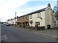
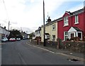
1
Landkey : Newland
A road heading through the village.
Image: © Lewis Clarke
Taken: 22 Dec 2016
0.05 miles
2
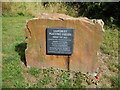
Landkey Playing Fields
Commemorative plaque of opening of Landkey Playing Fields in 1958.
Image: © Charles Fowler
Taken: 3 Aug 2013
0.10 miles
5
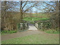
Footbridge on the Millennium Green
The area contains sport and play areas and pathways for dog walking or jogging.
Image: © Anthony Vosper
Taken: 9 Mar 2019
0.12 miles
6
A waterway joining another waterway which runs into Venn Stream
This waterway has its source near Broomscott Farm and is one of a number of streams which eventually feed into Venn Stream.
Image: © Roger A Smith
Taken: 18 Nov 2012
0.12 miles
7

Swimbridge : Landkey Scenery
Looking across the countryside towards Landkey.
Image: © Lewis Clarke
Taken: 2 Mar 2020
0.12 miles
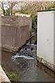
8
A waterway alongside Tanners Lane
This waterway, which joins Venn Stream, runs parallel to Tanners Lane before passing underneath and away north east towards its source at Gunn.
Image: © Roger A Smith
Taken: 18 Nov 2012
0.13 miles
9
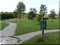
Tarka Trail public footpath finger post
A finger post where the Tarka Trail passes around the edge of Landkey's Millennium Green.
Image: © Charles Fowler
Taken: 3 Aug 2013
0.13 miles
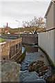
10

A stream running alongside Tanners Lane then under Blakes Hill Road
Shortly after passing under Blakes Hill Road this stream joins Venn Stream.
Image: © Roger A Smith
Taken: 18 Nov 2012
0.13 miles