IMAGES TAKEN NEAR TO
Landkey, BARNSTAPLE, EX32 0NP
Introduction
This page details the photographs taken nearby to EX32 0NP by members of the Geograph project.
The Geograph project started in 2005 with the aim of publishing, organising and preserving representative images for every square kilometre of Great Britain, Ireland and the Isle of Man.

There are currently over 7.5m images from over14,400 individuals and you can help contribute to the project by visiting https://www.geograph.org.uk
Image Map (Loading...)


Getting Data...Please wait
Leaflet Map data © OpenStreetMap
Images are licensed for reuse under creativecommons.org/licenses/by-sa/2.0
Notes
- Clicking on the map will re-center to the selected point.
- The higher the marker number, the further away the image location is from the centre of the postcode.
Image Listing (3 Images Found)
Images are licensed for reuse under creativecommons.org/licenses/by-sa/2.0
Image
Details
Distance
1
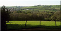
Woodland in the Venn Brook valley
Looking left from where Image] was taken, towards Swimbridge Newland.
Image: © Derek Harper
Taken: 4 May 2019
0.22 miles
2
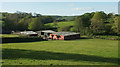
Vennaford Farm
Looking left from where Image] was taken, with farm buildings in the valley; the farmhouse is off to the left.
Image: © Derek Harper
Taken: 4 May 2019
0.23 miles
3
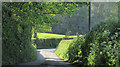
Lane to Hunnacott
See Image], this zooms in on the lit section of the lane ahead, where it passes a green lane on the left that cuts back to Hannaford.
Image: © Derek Harper
Taken: 4 May 2019
0.24 miles