IMAGES TAKEN NEAR TO
Bishops Tawton, BARNSTAPLE, EX32 0HB
Introduction
This page details the photographs taken nearby to EX32 0HB by members of the Geograph project.
The Geograph project started in 2005 with the aim of publishing, organising and preserving representative images for every square kilometre of Great Britain, Ireland and the Isle of Man.

There are currently over 7.5m images from over14,400 individuals and you can help contribute to the project by visiting https://www.geograph.org.uk
Image Map (Loading...)


Getting Data...Please wait
Leaflet Map data © OpenStreetMap
Images are licensed for reuse under creativecommons.org/licenses/by-sa/2.0
Notes
- Clicking on the map will re-center to the selected point.
- The higher the marker number, the further away the image location is from the centre of the postcode.
Image Listing (9 Images Found)
Images are licensed for reuse under creativecommons.org/licenses/by-sa/2.0
Image
Details
Distance
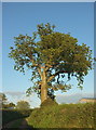
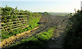
3
Green lane, Upcott Farm
The public access route / green lane to Woolstone, heading sunwards, and roughly a reverse view of Image
Image: © Derek Harper
Taken: 4 May 2019
0.02 miles
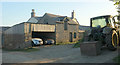
4
Barn, Upcott Farm
Looking the other way from where Image] was taken. The public access route / green lane is on the left.
Image: © Derek Harper
Taken: 4 May 2019
0.04 miles
5
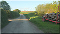
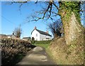
Lane at Upcott Farm
Not the only very minor lane in these parts to make a special detour to a single farm. At least it was in better condition than the one to Sideham Image
Image: © Derek Harper
Taken: 4 May 2019
0.04 miles
6
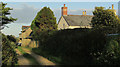
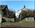
Upcott Farm
The public access route from Woolstone approaches the farm.
Image: © Derek Harper
Taken: 4 May 2019
0.04 miles
7
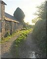
Upcott Farm
The public access route / green lane to Woolstone leaves the lane here.
Image: © Derek Harper
Taken: 4 May 2019
0.04 miles
9
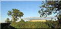
Tilled field, Upcott Farm
From the public access route / green lane to Woolstone where it makes sharp turn just west of the farm.
Image: © Derek Harper
Taken: 4 May 2019
0.15 miles