IMAGES TAKEN NEAR TO
Shirwell, BARNSTAPLE, EX31 4JT
Introduction
This page details the photographs taken nearby to EX31 4JT by members of the Geograph project.
The Geograph project started in 2005 with the aim of publishing, organising and preserving representative images for every square kilometre of Great Britain, Ireland and the Isle of Man.

There are currently over 7.5m images from over14,400 individuals and you can help contribute to the project by visiting https://www.geograph.org.uk
Image Map
Images are licensed for reuse under creativecommons.org/licenses/by-sa/2.0
Notes
- Clicking on the map will re-center to the selected point.
- The higher the marker number, the further away the image location is from the centre of the postcode.
Image Listing (16 Images Found)
Images are licensed for reuse under creativecommons.org/licenses/by-sa/2.0
Image
Details
Distance
1
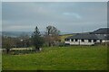
Shirwell : Grassy Field
A field near Shirwell Community Primary School.
Image: © Lewis Clarke
Taken: 21 Dec 2021
0.02 miles
2
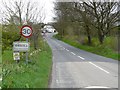
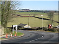
The northern edge of Shirwell Cross
Shirwell Cross is at a bend in the A39 where the road to Shirwell leads to the north-east. This is the view north from close to that junction
Image: © David Smith
Taken: 8 Jun 2015
0.04 miles
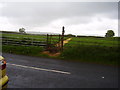
4
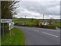
Wilkeys Corner on the A39 near Shirwell
Image: © Roger A Smith
Taken: 29 Apr 2008
0.05 miles
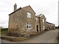
6
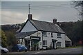
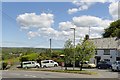
Shirwell : The Lodge
A building along the A39.
Image: © Lewis Clarke
Taken: 21 Dec 2021
0.06 miles
7
Footpath on the Shirwell Road
Cut grass marks the route across the field to Shirwell village.
On yet another gloomy Bank Holiday Saturday.
Image: © Anthony Vosper
Taken: 29 May 2010
0.14 miles
10
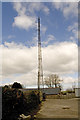
Radio Mast, Shirwell Cross
One of two radio masts in the village, a penalty of being so high.
Image: © Rabbi WP Thinrod
Taken: 17 Mar 2008
0.14 miles