IMAGES TAKEN NEAR TO
Raleigh Lawn, BARNSTAPLE, EX31 1PS
Introduction
This page details the photographs taken nearby to Raleigh Lawn, EX31 1PS by members of the Geograph project.
The Geograph project started in 2005 with the aim of publishing, organising and preserving representative images for every square kilometre of Great Britain, Ireland and the Isle of Man.

There are currently over 7.5m images from over14,400 individuals and you can help contribute to the project by visiting https://www.geograph.org.uk
Image Map (Loading...)


Getting Data...Please wait
Leaflet Map data © OpenStreetMap
Images are licensed for reuse under creativecommons.org/licenses/by-sa/2.0
Notes
- Clicking on the map will re-center to the selected point.
- The higher the marker number, the further away the image location is from the centre of the postcode.
Image Listing (198 Images Found)
Images are licensed for reuse under creativecommons.org/licenses/by-sa/2.0
Image
Details
Distance

2

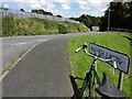
Raleigh Lawn near its junction with Higher Raleigh Road
Image: © Roger A Smith
Taken: 20 Jul 2012
0.02 miles
3

Raleigh Heights at the end of Raleigh Lawn
Image: © Roger A Smith
Taken: 20 Jul 2012
0.04 miles
4
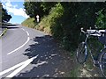
Looking down Higher Raleigh Road from Raleigh Lawn
Image: © Roger A Smith
Taken: 20 Jul 2012
0.06 miles
5

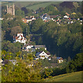
A view towards Barnstaple from the monument on Codden Hill
See also: Image
Image: © Roger A Smith
Taken: 10 Mar 2010
0.06 miles
6
Higher Raleigh Road near its junction with North Road
Image: © Roger A Smith
Taken: 20 Jul 2012
0.06 miles
7

Barnstaple : North Road A39
Heading along North Road.
Image: © Lewis Clarke
Taken: 21 Dec 2021
0.06 miles
8
The centre of this image is approximately where Higher Raleigh Road crosses North Road
To the left is the tower of St. Mary's Church, Pilton. To the right are allotment gardens.
Image: © Roger A Smith
Taken: 17 May 2023
0.08 miles
9

Higher Raleigh Road near its junction with The Rock
Image: © Roger A Smith
Taken: 20 Jul 2012
0.08 miles
10
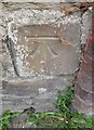
Ordnance Survey Cut Mark
This OS cut mark can be found on the NW side of Littabourne. It marks a point 30.413m above mean sea level.
Image: © Adrian Dust
Taken: 8 Jul 2016
0.09 miles