IMAGES TAKEN NEAR TO
Ebford, EXETER, EX3 0PA
Introduction
This page details the photographs taken nearby to EX3 0PA by members of the Geograph project.
The Geograph project started in 2005 with the aim of publishing, organising and preserving representative images for every square kilometre of Great Britain, Ireland and the Isle of Man.

There are currently over 7.5m images from over14,400 individuals and you can help contribute to the project by visiting https://www.geograph.org.uk
Image Map
Images are licensed for reuse under creativecommons.org/licenses/by-sa/2.0
Notes
- Clicking on the map will re-center to the selected point.
- The higher the marker number, the further away the image location is from the centre of the postcode.
Image Listing (82 Images Found)
Images are licensed for reuse under creativecommons.org/licenses/by-sa/2.0
Image
Details
Distance
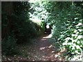
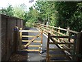
1
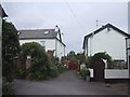
Houses near the Clyst
Unlikely footpath, but the right of way goes down the right-hand side of the closed gate
Image: © Sarah Charlesworth
Taken: 8 Sep 2008
0.01 miles
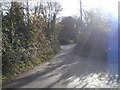

5
Orange Way in Devon and Torbay (293)
This public right of way now has to be shared by walkers (for whom it was originally designated) with pedal cyclists. I took advantage of a brief wheel-free spell to take this photograph. Such a narrow bendy path is wholly unsuitable for joint use. See also rant at Image
Image: © Shazz
Taken: 19 Nov 2011
0.04 miles
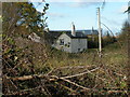
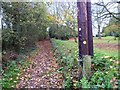
6
Footpath past "Four Winds"
"Four Winds" looks over the Exe, about 500 metres west of Ebford.
Image: © David Smith
Taken: 8 Jul 2010
0.04 miles

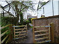
8
Newly extended footpath near Darts Farm
This is intended to link to the Exe Estuary Trail; the path has been surfaced to be used by cyclists, but retains several signs claiming it is a footpath.
Image: © David Smith
Taken: 8 Jul 2010
0.05 miles
9

Bridge over a Creek of the Clyst
The bridge is probably an old railway bridge on the sidings for the works has been adapted for vehicles.
Image: © Sarah Charlesworth
Taken: 8 Sep 2008
0.07 miles
10
Orange Way in Devon and Torbay (294)
Having reached a crosstracks where the guide book directed me to the left I decided to go the long way round up this proper footpath and escape from the dangers of the "shared path" with pedal cyclists.
Image: © Shazz
Taken: 19 Nov 2011
0.08 miles