IMAGES TAKEN NEAR TO
Lower Shapter Street, EXETER, EX3 0AT
Introduction
This page details the photographs taken nearby to Lower Shapter Street, EX3 0AT by members of the Geograph project.
The Geograph project started in 2005 with the aim of publishing, organising and preserving representative images for every square kilometre of Great Britain, Ireland and the Isle of Man.

There are currently over 7.5m images from over14,400 individuals and you can help contribute to the project by visiting https://www.geograph.org.uk
Image Map
Images are licensed for reuse under creativecommons.org/licenses/by-sa/2.0
Notes
- Clicking on the map will re-center to the selected point.
- The higher the marker number, the further away the image location is from the centre of the postcode.
Image Listing (413 Images Found)
Images are licensed for reuse under creativecommons.org/licenses/by-sa/2.0
Image
Details
Distance
1
![Higher Shapter Street, Topsham [2]](https://s1.geograph.org.uk/geophotos/01/30/90/1309085_cb1f24fd_120x120.jpg)
Higher Shapter Street, Topsham [2]
Looking towards the River Exe. For the view from the end of the street see http://www.geograph.org.uk/photo/1302690 .
Image: © Robin Drayton
Taken: 11 May 2009
0.02 miles
2
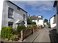
Higher Shapter Street, Topsham
A narrow street with some 18th century houses; the road was extended in the mid-twentieth century, when houses were built on the former orchards at the north-east end of the street
Image: © David Smith
Taken: 22 Aug 2016
0.02 miles
3

Group of houses in Higher Shapter Street, Topsham
The houses in this group are listed buildings, mentioning the visual effect of the group. The nearest has the date 1719 on the lintel. Next door there are two blind windows, which are glazed with black paint behind. Car number-plate blurred for security
Image: © David Smith
Taken: 22 Aug 2016
0.03 miles
6

Grade II listed buildings, Higher Shapter Street, Topsham
The listing for the row of houses refers to them being dissimilar, but that they form part of a group. The white house has two false windows, glazed with black recesses behind. Number plates blurred for security
Image: © David Smith
Taken: 22 Aug 2016
0.03 miles
7
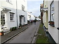
Higher Shapter Street, Topsham
This narrow street climbs away at right angles (like several others) from The Strand.
Image: © Derek Harper
Taken: 21 Oct 2006
0.03 miles
8

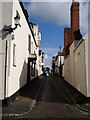
North Street, Topsham
A very narrow street leading off Higher Shapter Street; the old pump remains outside one house
Image: © David Smith
Taken: 22 Aug 2016
0.04 miles
9
![Higher Shapter Street, Topsham [1]](https://s2.geograph.org.uk/geophotos/01/30/90/1309082_363f14a6_120x120.jpg)
Higher Shapter Street, Topsham [1]
This street contains many listed buildings
It is named after Dr Thomas Shapter (1809-1902) who was twice Mayor of Exeter
and wrote the "History of the Cholera in Exeter in 1832".
Image: © Robin Drayton
Taken: 11 May 2009
0.04 miles
10
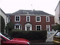
Topsham Museum
Looking across its garden at the Museum building in The Strand which is a former merchants house. It has an interesting local history collection. Lower Shapter Street is on the left.
Image: © Adrian Platt
Taken: 14 Feb 2009
0.04 miles