IMAGES TAKEN NEAR TO
Dunchideock, EXETER, EX2 9TP
Introduction
This page details the photographs taken nearby to EX2 9TP by members of the Geograph project.
The Geograph project started in 2005 with the aim of publishing, organising and preserving representative images for every square kilometre of Great Britain, Ireland and the Isle of Man.

There are currently over 7.5m images from over14,400 individuals and you can help contribute to the project by visiting https://www.geograph.org.uk
Image Map
Images are licensed for reuse under creativecommons.org/licenses/by-sa/2.0
Notes
- Clicking on the map will re-center to the selected point.
- The higher the marker number, the further away the image location is from the centre of the postcode.
Image Listing (13 Images Found)
Images are licensed for reuse under creativecommons.org/licenses/by-sa/2.0
Image
Details
Distance
1
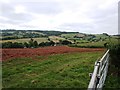
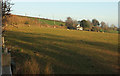
Newly ploughed field next to Manstree Road
Looking towards Dunchideock
Image: © David Gearing
Taken: 20 Sep 2013
0.10 miles
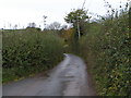
2
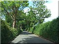
Road north-east of Manstree Cross on the way to Ide
Image: © David Smith
Taken: 30 May 2011
0.16 miles
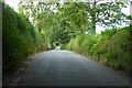
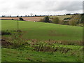
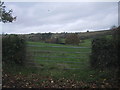
8
Track to Bowhay Farm
From the same place as Image], looking right down the valley. The stream that created the valley and runs among the trees to the right of the track is named as the Matford Brook some distance downstream, and has no other name in its upper course, so, for me, it's the Matford Brook. The track is not a right of way.
Image: © Derek Harper
Taken: 16 Jun 2016
0.23 miles
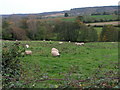
9
Sheep and cottage, Dunchideock
Looking left from where Image] was taken, with the lane down the Kenn valley behind the hedge on the left.
Image: © Derek Harper
Taken: 15 Feb 2019
0.23 miles
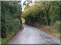
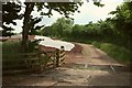
10
Field gate south of Manstree Cross
Image: © Sarah Charlesworth
Taken: 19 Nov 2009
0.23 miles