IMAGES TAKEN NEAR TO
The Firs, EXETER, EX2 9TD
Introduction
This page details the photographs taken nearby to The Firs, EX2 9TD by members of the Geograph project.
The Geograph project started in 2005 with the aim of publishing, organising and preserving representative images for every square kilometre of Great Britain, Ireland and the Isle of Man.

There are currently over 7.5m images from over14,400 individuals and you can help contribute to the project by visiting https://www.geograph.org.uk
Image Map
Images are licensed for reuse under creativecommons.org/licenses/by-sa/2.0
Notes
- Clicking on the map will re-center to the selected point.
- The higher the marker number, the further away the image location is from the centre of the postcode.
Image Listing (26 Images Found)
Images are licensed for reuse under creativecommons.org/licenses/by-sa/2.0
Image
Details
Distance

2

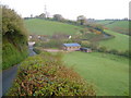
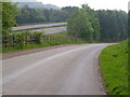
Black Hat Lane
The no through road begins by bending from its junction with Baker's Hill. I then drops to Little Valley before climbing steeply past the pylon in the background.
Image: © Derek Harper
Taken: 4 May 2006
0.05 miles
3
Shelter, B3212
I don't think this serves as a bus shelter; no bus stop is marked here on the map based on the National Public Transport Data Repository. It stands on Baker's Hill between the junctions with Black Hat Lane (behind the camera) and Westwood Lane. In the background is Image
Image: © Derek Harper
Taken: 4 May 2006
0.07 miles
4
Black Hat Lane from Westwood Lane
Two no through lanes shortly to meet at the B3212, here separated by Little Valley.
Image: © Derek Harper
Taken: 4 May 2006
0.07 miles
5
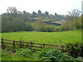
Little Valley Animal Shelter, Black Hat Lane
Black Hat Lane descends to pass the shelter buildings as it crosses the valley and climbs the far ridge to Charlista.
Image: © Derek Harper
Taken: 4 May 2006
0.07 miles
6
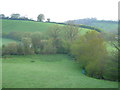
Where two valleys meet
The lines of trees show where two small streams meet from the valleys either side of the Black Hat Lane ridge.
Image: © Derek Harper
Taken: 4 May 2006
0.07 miles
7

Teignbridge : Bakers Hill
From the A30 looking down towards Bakers Hill in the Teignbridge District.
Image: © Lewis Clarke
Taken: 23 Feb 2014
0.09 miles
8

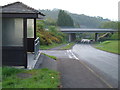
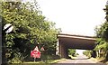
A30 Overbridge, Pocombe Bridge, Exeter
A30 Overbridge, Pocombe Bridge, Exeter. The actual Pocombe Bridge lies at the bottom of the hill.
Image: © Kevin Hale
Taken: 21 Nov 2005
0.09 miles
10
Westwood Lane and the A30
Diverted because of the A30 and thus made generously large for a no through road to three farms, this farm road runs beside the dual carriageway.
Image: © Derek Harper
Taken: 4 May 2006
0.11 miles