IMAGES TAKEN NEAR TO
Hambeer Lane, EXETER, EX2 9PH
Introduction
This page details the photographs taken nearby to Hambeer Lane, EX2 9PH by members of the Geograph project.
The Geograph project started in 2005 with the aim of publishing, organising and preserving representative images for every square kilometre of Great Britain, Ireland and the Isle of Man.

There are currently over 7.5m images from over14,400 individuals and you can help contribute to the project by visiting https://www.geograph.org.uk
Image Map
Images are licensed for reuse under creativecommons.org/licenses/by-sa/2.0
Notes
- Clicking on the map will re-center to the selected point.
- The higher the marker number, the further away the image location is from the centre of the postcode.
Image Listing (42 Images Found)
Images are licensed for reuse under creativecommons.org/licenses/by-sa/2.0
Image
Details
Distance
1

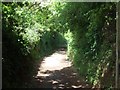
Start of Hambeer Lane in Exeter
This lane leads to a few houses, and then becomes a footpath, supposedly along the ancient ridgeway. It is now part of the "Exeter Green Circle"
Image: © David Smith
Taken: 16 May 2009
0.02 miles
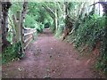
2
Hambeer Lane, Exeter
Part of the Exeter Green Circle footpath
Image: © David Smith
Taken: 16 May 2009
0.02 miles
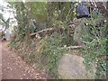
3

Hambeer Lane; one of two trig points
There are two trig point pillars by the footpath, both overgrown. This is the northern one, not marked on maps.
Image: © David Smith
Taken: 19 Sep 2016
0.04 miles
4
Hambeer Lane; one of two trig points
There are two trig point pillars by the footpath, both overgrown. This is the southern one, which is marked on maps.
Image: © David Smith
Taken: 19 Sep 2016
0.06 miles

6
Hambeer Lane, Exeter
Part of the Exeter Green Circle footpath
Image: © David Smith
Taken: 16 May 2009
0.07 miles
7
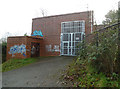
Building by service reservoir
Off Dunsford Road, Exeter. In the pouring rain.
Image: © Chris Allen
Taken: 27 Dec 2013
0.07 miles
8
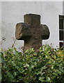
Old Wayside Cross by the B3212, St Thomas, Exeter
Little John's Cross, old head and shaft by the B3212, in parish of Exeter (Exeter District), St Thomas, on Little John's Cross Hill, behind a hedge and garden wall, at junction with Dunsford Road.
See https://www.flickr.com/photos/tollhouses/3281064901 for a different view, taken the same day.
Grade II listed.
List Entry Number: 1273779 https://historicengland.org.uk/listing/the-list/list-entry/1273779
Surveyed
Milestone Society National ID: DVEX_EXE01
Image: © Alan Rosevear
Taken: 15 Feb 2009
0.08 miles
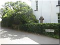
9

Convenience store, at the top of Dunsford Hill
Image: © Roger Cornfoot
Taken: 20 May 2010
0.08 miles
10
Littlejohn's Cross, on Little John's Cross Hill
As explained in Image, this cross takes its name from a man called Littlejohn.
Image: © David Smith
Taken: 7 Aug 2016
0.08 miles