IMAGES TAKEN NEAR TO
Ide Lane, EXETER, EX2 8UP
Introduction
This page details the photographs taken nearby to Ide Lane, EX2 8UP by members of the Geograph project.
The Geograph project started in 2005 with the aim of publishing, organising and preserving representative images for every square kilometre of Great Britain, Ireland and the Isle of Man.

There are currently over 7.5m images from over14,400 individuals and you can help contribute to the project by visiting https://www.geograph.org.uk
Image Map
Images are licensed for reuse under creativecommons.org/licenses/by-sa/2.0
Notes
- Clicking on the map will re-center to the selected point.
- The higher the marker number, the further away the image location is from the centre of the postcode.
Image Listing (38 Images Found)
Images are licensed for reuse under creativecommons.org/licenses/by-sa/2.0
Image
Details
Distance
1
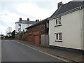
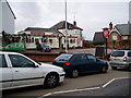
Old stone wall in Ide Lane, Alphington
Was this originally a boundary wall, adapted, or the roadside wall of a building?
Image: © David Smith
Taken: 4 Apr 2020
0.02 miles
2
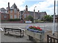
Former school, Alphington
Looking from the triangular island in front of Alphington church. In the foreground is a horse trough and beyond the road is the former school, now Alphington Community Centre and used by Alphington Primary Pre-School (on the banner)
Image: © David Smith
Taken: 7 Aug 2016
0.04 miles
3
Alphington: former school, now pre-school
The building is also used by the local community.
Image: © David Smith
Taken: 16 May 2009
0.05 miles
4
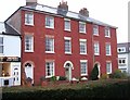
Listed terrace, Alphington
Numbers 2-6 Chudleigh Road are described at https://www.historicengland.org.uk/listing/the-list/list-entry/1104035 . At the far end is the junction with Ide Lane.
Image: © Derek Harper
Taken: 31 Mar 2006
0.05 miles
5
The New Inn, Church Road
In 1872 when the first Alphington Post Office moved The New Inn opened in the vacant building. In 1967 the original building was demolished and the pub moved into this extended 1930s style house next door.
Image: © Peter Holmes
Taken: 15 Nov 2008
0.06 miles
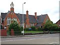
6
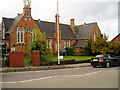
Alphington Community Centre, Church Road
A Grade II listed building erected in 1876 as Alphington Board School, at a cost of £2,300 which included the teacher's residence. The school was closed in 1987.
Image: © Peter Holmes
Taken: 15 Nov 2008
0.07 miles
7
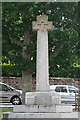
Old Wayside Cross - moved to Church Road, Alphington
War Memorial, old head in a new cross by the UC road, in parish of Exeter (Exeter District), Church Road, in the centre of Alphington village, on an octagonal pedestal in a triangular grass area in front of the church.
Grade II listed.
List Entry Number: 1443076 https://historicengland.org.uk/listing/the-list/list-entry/1443076
Surveyed
Milestone Society National ID: DVEX_ALP03
Image: © Alan Rosevear
Taken: 19 Jul 2010
0.08 miles
8
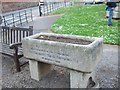
Horse trough in the centre of Alphington
It was erected to mark the coronation of King Edward VII in 1902
Image: © David Smith
Taken: 16 May 2009
0.09 miles
9
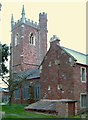
Church of St Michael, Alphington
Rather late on a gloomy evening, on the same occasion as Image The two-storey vestry on this southeast side seem unusual. The church is grade II* listed https://www.historicengland.org.uk/listing/the-list/list-entry/1103980 .
Image: © Derek Harper
Taken: 31 Mar 2006
0.09 miles
10

Old Wayside Cross - moved to Alphington churchyard, Exeter Parish
Alphington Churchyard Cross, old shaft, by the footpath, in parish of Exeter (Exeter District), leaning against the South East side of Alphington church tower, on grass.
Surveyed
Milestone Society National ID: DVEX_ALP01
Image: © Alan Rosevear
Taken: 11 May 2009
0.09 miles