IMAGES TAKEN NEAR TO
Steeple Drive, EXETER, EX2 8FL
Introduction
This page details the photographs taken nearby to Steeple Drive, EX2 8FL by members of the Geograph project.
The Geograph project started in 2005 with the aim of publishing, organising and preserving representative images for every square kilometre of Great Britain, Ireland and the Isle of Man.

There are currently over 7.5m images from over14,400 individuals and you can help contribute to the project by visiting https://www.geograph.org.uk
Image Map
Images are licensed for reuse under creativecommons.org/licenses/by-sa/2.0
Notes
- Clicking on the map will re-center to the selected point.
- The higher the marker number, the further away the image location is from the centre of the postcode.
Image Listing (22 Images Found)
Images are licensed for reuse under creativecommons.org/licenses/by-sa/2.0
Image
Details
Distance
1
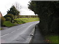
Leaving Alphington, back into the 30mph zone
Image: © Rob Purvis
Taken: 11 Nov 2009
0.09 miles
2
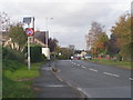
20 mph is Sooo Sloooow on this road, no wonder people are driving faster
30mph seems a much better speed limit on this type of road
Image: © Rob Purvis
Taken: 11 Nov 2009
0.11 miles
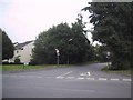
3

Children's playground, Chantry Meadow, Alphington
Image: © David Smith
Taken: 17 Nov 2010
0.13 miles
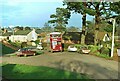
4
The Old Main Road to Dawlish
Now a useful short cut, hence the width restriction.
Image: © Sarah Charlesworth
Taken: 25 Sep 2008
0.16 miles

6

Parish Boundary Stone on Chudleigh Road, Alphington
Parish Boundary Marker by the UC road, in parish of Exeter (Exeter District), Chudleigh Road, Alphington, by No. 76 at junction with Markham Lane, on apex angle at foot of high stone wall on West side of road.
Inscription reads:-
: Exmins / -ter / P. : : Alphing / -ton / P. :
Devon & Dartmoor HER No: MDV80574 https://www.heritagegateway.org.uk/Gateway/Results_Single.aspx?uid=MDV80574&resourceID=104
Surveyed
Milestone Society National ID: DV_EXCH01pb
Image: © Alan Rosevear
Taken: 18 Apr 2011
0.17 miles
7
Former Exeter City Transport bus at Alphington terminus ? 1973
At the time this was the edge of residential development and Shillingford Road was still little more than a country lane. The road has since been widened and the location is unrecognisable. The bus is about to reverse into Fairfield Road on the left before crossing the city to Pennsylvania on route K. Exeter was unusual in using route letters rather than numbers. Exeter sold its municipal buses to Devon General in 1970, and here former Exeter 86, now 286, is seen repainted into the traditional Devon General red and white livery although with fleet name in the standard National Bus Company style. It is a Leyland PD2 with Massey bodywork, new in 1963. This is one of a series of views featuring buses in the 60s, 70s, and 80s. http://www.geograph.org.uk/search.php?i=137652761
Image: © Alan Murray-Rust
Taken: 24 Feb 1973
0.17 miles
8

The Gables
An early C19 listed building of "picturesque appearance" https://www.historicengland.org.uk/listing/the-list/list-entry/1104036 , also shown in Image The lane is Markham Lane, which reaches Chudleigh Road immediately beyond it. This is the boundary between Exeter (left) and Teignbridge districts.
Image: © Derek Harper
Taken: 31 Mar 2006
0.18 miles
9
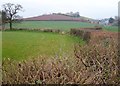
Farmland southeast of Alphington
From further west than Image] along Exminster footpath 60. The hedge in the foreground and that to the left are followed by the boundary between Exeter (left) and Teignbridge districts. On the right is Matford House. Knowle Hill is straight ahead.
Image: © Derek Harper
Taken: 31 Mar 2006
0.19 miles
10
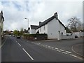
Thatched house in Alphington
Typical farmhouse design with a gabled porch
Image: © David Smith
Taken: 4 Apr 2020
0.20 miles