IMAGES TAKEN NEAR TO
Bishops Way, EXETER, EX2 7PF
Introduction
This page details the photographs taken nearby to Bishops Way, EX2 7PF by members of the Geograph project.
The Geograph project started in 2005 with the aim of publishing, organising and preserving representative images for every square kilometre of Great Britain, Ireland and the Isle of Man.

There are currently over 7.5m images from over14,400 individuals and you can help contribute to the project by visiting https://www.geograph.org.uk
Image Map
Images are licensed for reuse under creativecommons.org/licenses/by-sa/2.0
Notes
- Clicking on the map will re-center to the selected point.
- The higher the marker number, the further away the image location is from the centre of the postcode.
Image Listing (101 Images Found)
Images are licensed for reuse under creativecommons.org/licenses/by-sa/2.0
Image
Details
Distance

2
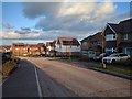
New houses at Sandy Park, unfinished road surface
Image: © Rob Purvis
Taken: 1 Feb 2018
0.01 miles
3

Sandy Way, Exeter
A T junction on the cul-de-sac shown in Image], from Apple Lane. The branch ahead meets Bishop's Way in the background.
Image: © Derek Harper
Taken: 3 Jun 2017
0.01 miles
4

Bishop's Way, Exeter
The western extremity, for the moment, anyway, of the main artery of this housing estate largely built in the disused Bishop's Court sandstone quarry. the other end of the road is shown in Image View from the path shown in Image], looking left.
Image: © Derek Harper
Taken: 3 Jun 2017
0.02 miles
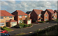
5

New houses now occupied, but the road surface isn't finished
Image: © Rob Purvis
Taken: 1 Feb 2018
0.02 miles
6

Sandy Way, Exeter
From Apple Lane, the path on the left leading to Apple Lane, the industrial estate, with a branch path into the new housing off Bishop's Way. The houses are also shown in Image] and Image
Image: © Derek Harper
Taken: 3 Jun 2017
0.03 miles
7
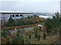
Trade City, Exeter, one of the warehouses
A warehouse and offices in Apple Lane, a recent extension of Sowton Industrial Estate.
Image: © David Smith
Taken: 30 Oct 2009
0.04 miles
8

The path from Sandy Park heading towards Digby and Sowton station, new houses being built on the left
Image: © Rob Purvis
Taken: 1 Feb 2018
0.05 miles
9
Sandy Way, Exeter
Seen from a few yards further southwest along Apple Lane than Image From the point of the pedestrian or cyclist, or indeed from the landscape perspective, Sandy Way and Sandstone Close form one road, but not if you are in a car. Thanks to Open Street Map for being, as far as I can see, the only online source to name this road.
Image: © Derek Harper
Taken: 3 Jun 2017
0.05 miles
10
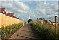
Path to Sandy Park
Showing the path turning left in Image], passing new housing on Bishop's Way on the left, and a building site on the right. Ahead is the Baker Bridge, a footbridge over the A379 Image
Image: © Derek Harper
Taken: 3 Jun 2017
0.05 miles