IMAGES TAKEN NEAR TO
Resolution Road, EXETER, EX2 7FG
Introduction
This page details the photographs taken nearby to Resolution Road, EX2 7FG by members of the Geograph project.
The Geograph project started in 2005 with the aim of publishing, organising and preserving representative images for every square kilometre of Great Britain, Ireland and the Isle of Man.

There are currently over 7.5m images from over14,400 individuals and you can help contribute to the project by visiting https://www.geograph.org.uk
Image Map
Images are licensed for reuse under creativecommons.org/licenses/by-sa/2.0
Notes
- Clicking on the map will re-center to the selected point.
- The higher the marker number, the further away the image location is from the centre of the postcode.
Image Listing (59 Images Found)
Images are licensed for reuse under creativecommons.org/licenses/by-sa/2.0
Image
Details
Distance
1

New housing at Newcourt
Houses nearing completion at the northeastern corner of the development site shown in Image, seen through a fence from Exeter Footpath 19. The site was formerly a Royal Navy Stores Depot.
Image: © Derek Harper
Taken: 4 Nov 2009
0.03 miles
2
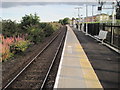
Newcourt railway station, Devon
Opened in 2015 by Network Rail on the line from Exeter to Exmouth.
View south towards Topsham and Exmouth.
Image: © Nigel Thompson
Taken: 31 Jul 2015
0.06 miles
3
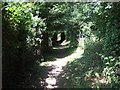
Footpath beside railway line
This footpath links Old Rydon Lane, on the edge of Exeter with Topsham beside the railway line.
Image: © David Smith
Taken: 1 Jul 2009
0.06 miles

5

The Fairways
A new development of housing across Old Rydon Lane from Image; the scene up the lane on the left also appears in Image Good that they have managed to retain laneside oaks.
Image: © Derek Harper
Taken: 4 Nov 2009
0.07 miles
6

Old Rydon Lane
Housing on the lane which runs parallel to the A379 and links Clyst Road with Countess Wear, with scattered development that is now increasing rapidly. These houses are on a small cul-de-sac of 16 properties, Old Rydon Ley.
Image: © Derek Harper
Taken: 4 Nov 2009
0.07 miles
7
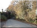
Railway Bridge, Old Rydon Lane, Exeter
The line from Exeter to Exmouth is now known as the "Avocet Line".
Image: © David Smith
Taken: 15 Dec 2005
0.07 miles
8

New housing development in Old Rydon Lane
A popular location with easy access into the city and to the M5.
Image: © Rod Allday
Taken: 17 Aug 2010
0.07 miles
9

Old Rydon Ley / Lane
A further view of Image from Image, looking in the other direction up the lane. The roadwork sign relates to temporary traffic lights for ongoing work at Image; the entrance is immediately behind the camera.
Image: © Derek Harper
Taken: 4 Nov 2009
0.08 miles
10

Development at Newcourt
A large development site described recently in the local press thus: "Newcourt, set aside for 3,700 homes and 20 hectares of employment land with a new centre to the south of Old Rydon Lane, as well as shops and community facilities. Two primary schools, a doctors’ surgery and a bus and rail interchange are also proposed" http://www.thisisexeter.co.uk/housing/Exeter-hunts-land-15-000-homes/article-1438520-detail/article.html . This site is on the other side of Exeter Footpath 19 from Image
Image: © Derek Harper
Taken: 4 Nov 2009
0.08 miles