IMAGES TAKEN NEAR TO
St. Pauls Close, Burnthouse Lane, EXETER, EX2 6EL
Introduction
This page details the photographs taken nearby to St. Pauls Close, Burnthouse Lane, EX2 6EL by members of the Geograph project.
The Geograph project started in 2005 with the aim of publishing, organising and preserving representative images for every square kilometre of Great Britain, Ireland and the Isle of Man.

There are currently over 7.5m images from over14,400 individuals and you can help contribute to the project by visiting https://www.geograph.org.uk
Image Map
Images are licensed for reuse under creativecommons.org/licenses/by-sa/2.0
Notes
- Clicking on the map will re-center to the selected point.
- The higher the marker number, the further away the image location is from the centre of the postcode.
Image Listing (92 Images Found)
Images are licensed for reuse under creativecommons.org/licenses/by-sa/2.0
Image
Details
Distance
1
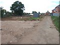
The site of St Paul's Church, Burnthouse Lane
The former church Image] has been demolished. The last service was on Easter Day 2010. The site will be used for housing, a community centre and a worship centre.
Image: © David Smith
Taken: 11 Sep 2010
0.01 miles
2
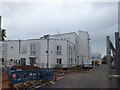
New houses and flats on the site of St Paul's church
The former site of St Paul's church has been redeveloped to provide affordable housing. A community centre is planned on part of the site.
Image: © David Smith
Taken: 10 Sep 2011
0.01 miles
3

St Paul's Church, Burnthouse Lane, Exeter
This is a daughter church of the parish church of Heavitree
Image: © David Smith
Taken: 8 Sep 2007
0.01 miles
4
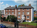
203-205 Topsham Road, Exeter
A late Georgian pair with Tuscan porches. A few smaller contemporaries lie a little way west. Grade II listed.
Image: © Stephen Richards
Taken: 18 Jun 2014
0.04 miles
5
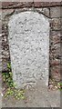
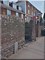
Old Milestone by the A3015, Topsham Road, Exeter
Carved stone post by the A3015, in parish of EXETER (EXETER District), Topsham Road, 30m West of Burnthouse Lane, opposite Earl Richard's Road South, built into brick wall by bus stop, on North-east side of road. Exeter tombstone, erected by the Exeter Turnpike Trust in the 18th century.
Inscription reads:-
1
MILE
TO
EXETER
Carved benchmark on front base.
Milestone Society National ID: DV_EXTP01.
Image: © Milestone Society
Taken: 27 Jan 2017
0.05 miles
6
Milestone, one mile from Exeter, Topsham Road
Image: © David Smith
Taken: 25 Apr 2020
0.05 miles
7

Milestone set into a wall on Topsham Road, Exeter
This worn stone advises that it is 1 mile from here to Exeter. A matching stone is found two miles further on Image - the intermediate one appears to be lost
Image: © David Smith
Taken: 23 Oct 2015
0.05 miles
8
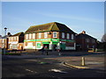
Londis stores Burnthouse lane
At one point there was a shop on three of the four points of this crossroads the fourth was and is still occupied by a public house.
Image: © Anthony Vosper
Taken: 13 Jan 2013
0.06 miles
9
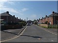
Chaucer Avenue. cul-de-sac off Shakespeare Road, Exeter
Image: © David Smith
Taken: 11 Apr 2020
0.06 miles
