
IMAGES TAKEN NEAR TO
Ivy Close, EXETER, EX2 5LX
Introduction
This page details the photographs taken nearby to Ivy Close, EX2 5LX by members of the Geograph project.
The Geograph project started in 2005 with the aim of publishing, organising and preserving representative images for every square kilometre of Great Britain, Ireland and the Isle of Man.

There are currently over 7.5m images from over14,400 individuals and you can help contribute to the project by visiting https://www.geograph.org.uk
Image Map
Images are licensed for reuse under creativecommons.org/licenses/by-sa/2.0
Notes
- Clicking on the map will re-center to the selected point.
- The higher the marker number, the further away the image location is from the centre of the postcode.
Image Listing (88 Images Found)
Images are licensed for reuse under creativecommons.org/licenses/by-sa/2.0
Image
Details
Distance
1
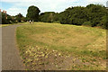
Open space by the Northbrook
The path, from Ludwell Lane, follows a narrow strip of open space between houses on Ivy Close on the left, and the stream on the right.
Image: © Derek Harper
Taken: 18 Jul 2020
0.02 miles
2
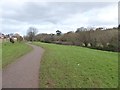
Path beside the Northbrook, Wonford, Exeter
A path between the houses of Ivy Close and the stream, part of the Valley Park
Image: © David Smith
Taken: 19 Feb 2016
0.02 miles
3
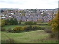
Housing estates in Heavitree, Exeter
Seen from the public footpath in Ludwell Valley Park; many of these houses were built in the 1930s
Image: © David Smith
Taken: 6 Nov 2016
0.03 miles

5
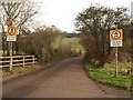
Traffic restriction signs, Ludwell Lane
A slightly unusual traffic restriction, aimed at stopping the use of Ludwell Lane as a rat run during the afternoon rush hour. See Image; the area is surprisingly rural, although surrounded by suburban estates and development. Photo taken from the bridge over Northbrook.
Image: © Derek Harper
Taken: 10 Jan 2009
0.06 miles
6
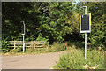
Covered signs, Ludwell Lane
See Image The signs have been concealed, but the lane is blocked as shown in Image https://exetercyclingcampaign.org.uk/wp-content/uploads/LivingStreetsExeter.pdf indicates the line of thinking. I imagine there are now no through road signs at the junction with Rifford Road.
Image: © Derek Harper
Taken: 18 Jul 2020
0.07 miles
7
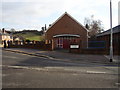
Ludwell Hall
This former church in Burnthouse Lane is now a community centre.
Image: © Anthony Vosper
Taken: 23 Jan 2010
0.07 miles
8
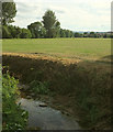
Northbrook at Ludwell Lane
Looking downstream, with playing fields on the right bank.
Image: © Derek Harper
Taken: 18 Jul 2020
0.07 miles
9
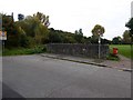
Bridge over Ludwell brook, Wonford, Exeter
The stream has a wide floodplain which is now open space for recreation. Between it and Exeter by-pass is a "valley park"
Image: © David Smith
Taken: 19 Oct 2015
0.07 miles
10
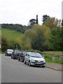
The foot of Ludwell Lane, Exeter
An old lane, now a single track road, which links the housing estates of Wonford in the Ludwell valley with Exeter by-pass; on the skyline is a phone mast disguised as a tree
Image: © David Smith
Taken: 19 Oct 2015
0.08 miles