IMAGES TAKEN NEAR TO
EX2 4XU
Introduction
This page details the photographs taken nearby to EX2 4XU by members of the Geograph project.
The Geograph project started in 2005 with the aim of publishing, organising and preserving representative images for every square kilometre of Great Britain, Ireland and the Isle of Man.

There are currently over 7.5m images from over14,400 individuals and you can help contribute to the project by visiting https://www.geograph.org.uk
Image Map
Images are licensed for reuse under creativecommons.org/licenses/by-sa/2.0
Notes
- Clicking on the map will re-center to the selected point.
- The higher the marker number, the further away the image location is from the centre of the postcode.
Image Listing (2274 Images Found)
Images are licensed for reuse under creativecommons.org/licenses/by-sa/2.0
Image
Details
Distance
1
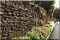
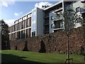
City walls, Exeter
Along Roman Walk, and certainly partly Roman http://demolition-exeter.blogspot.co.uk/2010/10/exeters-city-wall-2.html https://www.historicengland.org.uk/listing/the-list/list-entry/1003858 .
Image: © Derek Harper
Taken: 3 Oct 2017
0.01 miles
2
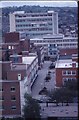
Old Princesshay, Exeter
A view from the roof of Exeter Cathedral during Exeter Festival 1979 (hence the flags) showing the pedestrian area and the high block of Debenhams.
Image: © David Smith
Taken: Unknown
0.01 miles
3

Debenhams store, Princesshay, Exeter
Outside the store is a temporary statue of a gorilla, part of a trail of about thirty similar decorated statues organised by Paignton Zoo
Image: © David Smith
Taken: 3 Aug 2013
0.02 miles
4
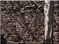
City walls, Roman Walk, Exeter
The angle of the sun brings out the different types of stonework in this stretch of wall on the fringe of the Princesshay development. The darker layer must be volcanic trap, with sandstone beneath.
Image: © Derek Harper
Taken: 25 Mar 2008
0.02 miles
5
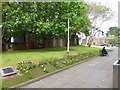
Floral lettering: Princesshay, Exeter
Flowers spelling out the name of the shopping centre, Princesshay, which is beyond the city wall on the left
Image: © David Smith
Taken: 25 May 2015
0.02 miles
6
City wall and Princesshay development
This view of the city wall has recently been re-revealed following the opening of the new shopping centre beyond. This section of the wall seems to be medieval or later.
Image: © Derek Harper
Taken: 23 Oct 2007
0.02 miles
7

Exeter : Roman Walk
Looking along Roman Walk as the sky was turning a nice shade of purple after sunset.
Image: © Lewis Clarke
Taken: 4 Feb 2016
0.02 miles
8

Jewellers, Princesshay, Exeter
The corner of Roman Walk (behind the camera) and Bedford Street, which actually forms a fairly large open space. The jewellers, Carol Anne, in whose window the open space is reflected, is an independent shop, which makes a nice change in a city reputed to be the worst clone town in the UK http://en.wikipedia.org/wiki/Clone_town .
Image: © Derek Harper
Taken: 8 Oct 2008
0.02 miles
9
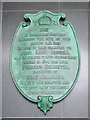
Plaque on Debenham's. Exeter
The plaque, dating from 1897 and now placed on the wall of an alcove on the side of Image, originally graced the lamented Bedford Circus, pulled down after being damaged in the war, and records its previous history. As the plaque explains, Bedford House was the birthplace in 1644 of Henrietta Anne Stuart, daughter of Charles I. The location's history is more fully documented at http://www.exetermemories.co.uk/EM/bedfordhouse.html .
Image: © Derek Harper
Taken: 7 Jan 2009
0.02 miles
10
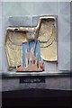
Exeter Phoenix in Princesshay, 1980
The symbol of the phoenix was used to represent the reconstruction of Exeter after the second world war. The text does not refer to any nationality, simply referring to "enemy action". A similar text was used for other plaques which marked reconstruction, a reminder of the desire for peace and reconciliation.
This sculpture appears to have been lost in the redevelopment of Princesshay.
Image: © David Smith
Taken: Unknown
0.02 miles