IMAGES TAKEN NEAR TO
College Avenue, EXETER, EX2 4TH
Introduction
This page details the photographs taken nearby to College Avenue, EX2 4TH by members of the Geograph project.
The Geograph project started in 2005 with the aim of publishing, organising and preserving representative images for every square kilometre of Great Britain, Ireland and the Isle of Man.

There are currently over 7.5m images from over14,400 individuals and you can help contribute to the project by visiting https://www.geograph.org.uk
Image Map
Images are licensed for reuse under creativecommons.org/licenses/by-sa/2.0
Notes
- Clicking on the map will re-center to the selected point.
- The higher the marker number, the further away the image location is from the centre of the postcode.
Image Listing (395 Images Found)
Images are licensed for reuse under creativecommons.org/licenses/by-sa/2.0
Image
Details
Distance

2
College Avenue, Exeter
Taking its name from the former St Luke's College, opposite, now the St Luke's campus of Exeter University
Image: © David Smith
Taken: 4 Mar 2016
0.01 miles
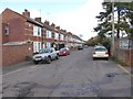
3

Raleigh Road, St Leonard's, Exeter
This one-way residential street has a right-angle turn towards the northern end. This is the view from College Road, with university buildings on the left including the "Giraffe House" Image
Image: © David Smith
Taken: 21 Apr 2016
0.03 miles
4
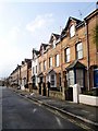
Raleigh Road, Exeter
Gable dormers make these terraced houses into 3 storeys. Seen from the point where the road turns a right-angle beside the edge of St Luke's campus.
Image: © Derek Harper
Taken: 4 Feb 2009
0.03 miles
5
The Richards Building, St Luke's campus, Exeter University
Image: © David Smith
Taken: 4 Mar 2016
0.03 miles
6

The Giraffe House, St Luke's Campus, University of Exeter
The building is nicknamed the Giraffe House from its similarity to buildings for giraffes in zoos with windows that only giraffes can look through (such as in London Image) It has been used for meetings and as a refectory
Image: © David Smith
Taken: 16 Jan 2015
0.03 miles
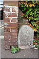
7

Old Parish Boundary Marker by Magdalen Road, Exeter Parish
Parish Boundary Marker by the UC road, in parish of Exeter (Exeter District), Magdalen Road, at junction with College Avenue, at back of pavement, beside end of brick wall, North side of road.
Inscription reads:- : 18 / H | P / (97 ) :
Surveyed
Milestone Society National ID: DV_EXHT01apb
Image: © Alan Rosevear
Taken: 17 Apr 2011
0.04 miles
8
Benchmark at end of wall on College Avenue
Ordnance Survey cut mark benchmark described on the Bench Mark Database at http://www.bench-marks.org.uk/bm40171
Image: © Roger Templeman
Taken: 23 Nov 2011
0.05 miles
9

Junction of Magdalen Road and College Avenue
On the end of the wall, beside a boundary stone, is an OS benchmark Image
Image: © Roger Templeman
Taken: 23 Nov 2011
0.05 miles
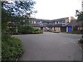
10
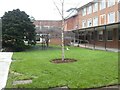
Courtyard with weather station, St Luke's Campus, Exeter
Image: © David Smith
Taken: 4 Mar 2021
0.06 miles