
IMAGES TAKEN NEAR TO
Curie Mews, EXETER, EX2 4TB
Introduction
This page details the photographs taken nearby to Curie Mews, EX2 4TB by members of the Geograph project.
The Geograph project started in 2005 with the aim of publishing, organising and preserving representative images for every square kilometre of Great Britain, Ireland and the Isle of Man.

There are currently over 7.5m images from over14,400 individuals and you can help contribute to the project by visiting https://www.geograph.org.uk
Image Map
Images are licensed for reuse under creativecommons.org/licenses/by-sa/2.0
Notes
- Clicking on the map will re-center to the selected point.
- The higher the marker number, the further away the image location is from the centre of the postcode.
Image Listing (242 Images Found)
Images are licensed for reuse under creativecommons.org/licenses/by-sa/2.0
Image
Details
Distance
1
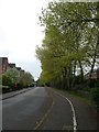
Trees showing fresh green leaves, Gras Lawn, Exeter
The line of trees on the left predates the housing estate on the right; the trees form one side of an abandoned track, now overgrown Image
Image: © David Smith
Taken: 17 Apr 2020
0.03 miles
2
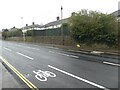
Newly marked cycle lane, Barrack Road, Exeter
As a guide for the engineers, a small cycle symbol was marked where the main symbol had to be stencilled. The road itself had been resurfaced a few days earlier
Image: © David Smith
Taken: 31 Jan 2021
0.04 miles
3
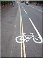
Unofficial lane markings, Barrack Road, Exeter
The protest group, Extinction Rebellion, painted extra cycle outlines in a cycle lane to make it into a "priority lane" approaching the hospital during the pandemic. These two are in white and blue; another was in red
Image: © David Smith
Taken: 3 Jun 2020
0.04 miles
4
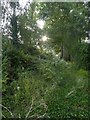
Overgrown lane off Barrack Road, Exeter
This lane formerly gave access to fields on each side; housing developments on each side have provided alternative routes for 21st century traffic.
Image: © David Smith
Taken: 2 Aug 2019
0.04 miles
5
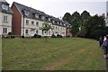
Exeter : Grassy Lawn
An open space beside the Grange and houses.
Image: © Lewis Clarke
Taken: 21 Sep 2012
0.05 miles
7
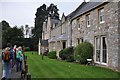
Exeter : The Grange
House; used as hospital. Circa 1838; by Samuel Alexander Greig, for James Veitch nurseryman; extended circa 1867 and again later in C19.
Image: © Lewis Clarke
Taken: 21 Sep 2012
0.05 miles

9

Archway, Fleming Way, Exeter
There is some quite imaginative estate design on the Wellingtonia Park development in eastern Exeter.
Image: © Derek Harper
Taken: 6 Feb 2008
0.05 miles
10
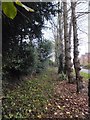
Disused lane at Gras Lawn
On 19th century maps, this lane provided access from Barrack Road to nursery buildings for the plant nurseries on the left. The lane became derelict and some of the trees probably date from the period when the area to the right was a playing field for Exeter University.
Image: © David Smith
Taken: 13 Nov 2011
0.05 miles