IMAGES TAKEN NEAR TO
Gras Lawn, EXETER, EX2 4SS
Introduction
This page details the photographs taken nearby to Gras Lawn, EX2 4SS by members of the Geograph project.
The Geograph project started in 2005 with the aim of publishing, organising and preserving representative images for every square kilometre of Great Britain, Ireland and the Isle of Man.

There are currently over 7.5m images from over14,400 individuals and you can help contribute to the project by visiting https://www.geograph.org.uk
Image Map
Images are licensed for reuse under creativecommons.org/licenses/by-sa/2.0
Notes
- Clicking on the map will re-center to the selected point.
- The higher the marker number, the further away the image location is from the centre of the postcode.
Image Listing (262 Images Found)
Images are licensed for reuse under creativecommons.org/licenses/by-sa/2.0
Image
Details
Distance
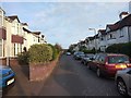
1

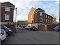
Part of Gras Lawn, Exeter (2)
A large development of apartments and town houses on Gras Lawn, formerly the estate of the Veitch family of Victorian nurserymen. These blocks form a circus around the central lawn
Image: © David Smith
Taken: 1 Nov 2015
0.01 miles
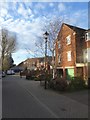
2
A block of townhouses arranged as a circle, Exeter
Part of the Gras Lawn estate, with four quadrants around a central lawn and car parking area; seen from diametrically opposite Image
Image: © David Smith
Taken: 27 Feb 2018
0.02 miles
3
Part of Gras Lawn, Exeter
The south west corner of a large block of townhouses
Image: © David Smith
Taken: 27 Feb 2018
0.04 miles
4

Repairs to part of Gras Lawn housing, Exeter
The west face of one block of townhouses in the Gras Lawn estate
Image: © David Smith
Taken: 27 Feb 2018
0.04 miles
5
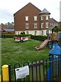
Exeter lockdown notice, playground in Gras Lawn
Image: © David Smith
Taken: 30 Apr 2020
0.05 miles
6
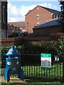
Litter bin, play area, Gras Lawn
A rocket-shaped litter bin at the side of the Gras Lawn play area in Exeter.
Image: © Derek Harper
Taken: 6 Feb 2008
0.05 miles
8
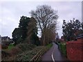
Cycle and foot-path, Gras Lawn, Exeter
The trees on the left border a disused lane, formerly used as access to the fields of Gras Lawn before the housing estate was built
Image: © David Smith
Taken: 20 Feb 2021
0.05 miles
9

Wellingtonia clump, off Fleming Way, Exeter
The trees date from the Victorian estate, used by the Veitch family (nurserymen). The nursery popularized Wellingtonia trees for British country estates
Image: © David Smith
Taken: 20 Feb 2021
0.05 miles
10
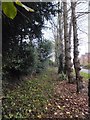
Disused lane at Gras Lawn
On 19th century maps, this lane provided access from Barrack Road to nursery buildings for the plant nurseries on the left. The lane became derelict and some of the trees probably date from the period when the area to the right was a playing field for Exeter University.
Image: © David Smith
Taken: 13 Nov 2011
0.05 miles