
IMAGES TAKEN NEAR TO
Gras Lawn, EXETER, EX2 4RZ
Introduction
This page details the photographs taken nearby to Gras Lawn, EX2 4RZ by members of the Geograph project.
The Geograph project started in 2005 with the aim of publishing, organising and preserving representative images for every square kilometre of Great Britain, Ireland and the Isle of Man.

There are currently over 7.5m images from over14,400 individuals and you can help contribute to the project by visiting https://www.geograph.org.uk
Image Map
Images are licensed for reuse under creativecommons.org/licenses/by-sa/2.0
Notes
- Clicking on the map will re-center to the selected point.
- The higher the marker number, the further away the image location is from the centre of the postcode.
Image Listing (222 Images Found)
Images are licensed for reuse under creativecommons.org/licenses/by-sa/2.0
Image
Details
Distance
1

Repairs to part of Gras Lawn housing, Exeter
The west face of one block of townhouses in the Gras Lawn estate
Image: © David Smith
Taken: 27 Feb 2018
0.02 miles
2
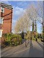
Trees between Barrack Road and Gras Lawn, Exeter
The south-east corner of the large block of town houses in Gras Lawn. The development is screened slightly from the road by the trees and an old wall
Image: © David Smith
Taken: 27 Feb 2018
0.03 miles
3
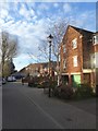
Part of Gras Lawn, Exeter
The south west corner of a large block of townhouses
Image: © David Smith
Taken: 27 Feb 2018
0.03 miles
4
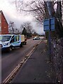
Barrack Road, Exeter; damage by Storm Eunice
Storm Eunice affected the south-west of England on February 18th 2022. It blew down a tree across Barrack Road in Exeter. Some wood chips from the clearance are visible, along with the lamp standard that was felled by the falling tree. The police car was waiting for an electrical engineering team
Image: © David Smith
Taken: 18 Feb 2022
0.03 miles
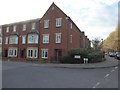
6
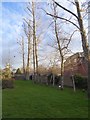
Trees at the southern edge of Gras Lawn housing estate
A slight screen between this estate and the neighbouring development; to the left is the clock tower of Wyvern Barracks Image
Image: © David Smith
Taken: 27 Feb 2018
0.03 miles
7

Entrance to Wyvern Barracks, Exeter
On the right is a WD boundary marker
Image: © David Smith
Taken: 3 Apr 2020
0.04 miles
8

WD boundary marker, Wyvern Barracks, Exeter
Image: © David Smith
Taken: 3 Apr 2020
0.04 miles
9
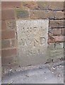
Old Boundary Marker by Barrack Road, Exeter parish
Estate Boundary Marker - War Department by the UC road, in parish of Exeter (Exeter District), Barrack Road, to right of North vehicle entrance to Wyvern Barracks, in brick boundary wall.
Inscription reads:-
1874
W^D
No.1
Surveyed
Milestone Society National ID: DV_EXWB01Wem
Image: © Alan Rosevear
Taken: 30 Mar 2013
0.04 miles
10
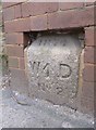
Old Boundary Marker by Barrack Road, Exeter parish
Estate Boundary Marker - War Department by the UC road, in parish of Exeter (Exeter District), Barrack Road, to left of North vehicle entrance to Wyvern Barracks, by pedestrian gate, in brick boundary pillar.
Inscription reads:-
1874
W^D
No 2
Devon & Dartmoor HER.
HER Number: MDV75142 https://www.heritagegateway.org.uk/Gateway/Results_Single.aspx?uid=MDV75142&resourceID=104
Surveyed
Milestone Society National ID: DV_EXWB02Wem
Image: © Alan Rosevear
Taken: 30 Mar 2013
0.04 miles