IMAGES TAKEN NEAR TO
Feltrim Avenue, EXETER, EX2 4RP
Introduction
This page details the photographs taken nearby to Feltrim Avenue, EX2 4RP by members of the Geograph project.
The Geograph project started in 2005 with the aim of publishing, organising and preserving representative images for every square kilometre of Great Britain, Ireland and the Isle of Man.

There are currently over 7.5m images from over14,400 individuals and you can help contribute to the project by visiting https://www.geograph.org.uk
Image Map
Images are licensed for reuse under creativecommons.org/licenses/by-sa/2.0
Notes
- Clicking on the map will re-center to the selected point.
- The higher the marker number, the further away the image location is from the centre of the postcode.
Image Listing (313 Images Found)
Images are licensed for reuse under creativecommons.org/licenses/by-sa/2.0
Image
Details
Distance
1
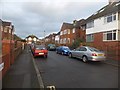
Bagshot Avenue, Exeter
A post-war suburban road south-east of the city centre of Exeter
Image: © David Smith
Taken: 5 Dec 2012
0.06 miles
3
View down Norwood Avenue, Exeter
The foot of the road overlooks Belle Isle Park and the River Exe, with the block of the Energy From Waste recycling centre on the left Image
Image: © David Smith
Taken: 1 Apr 2020
0.06 miles
4
Feltrim Avenue, off Topsham Road, Exeter
A residential road. A nearby house (now gone) was called Feltrim and there was also a nursery at the end of this road called Feltrim Nursery
Image: © David Smith
Taken: 2 Aug 2016
0.06 miles
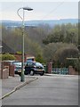
5
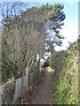
Foot and cycle path beside Belle Isle Park, Exeter
The fence on the left is the boundary of the park
Image: © David Smith
Taken: 16 Dec 2017
0.06 miles
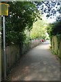
6
Orange Way in Devon and Torbay (253)
The Way takes a twitten parallel to the river.
Image: © Shazz
Taken: 17 Nov 2011
0.07 miles
7
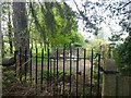
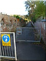
Old gateway to Belle Isle, Exeter
One of a pair of granite gateposts; beyond is the city council store of building stones for repairing walls
Image: © David Smith
Taken: 24 Apr 2020
0.07 miles
8
Houses in Norwood Avenue, Exeter
Seen from Glenwood Rise; a post-WW2 development of housing
Image: © David Smith
Taken: 1 Apr 2020
0.07 miles
9

The wall of County Hall, Exeter, facing Topsham Road
On the extreme left of the picture is a boundary stone, inscribed T.P.. The wall has been reconstructed (possibly at the time that the Devon County Council offices were built in the 1960s) and this stone is in the position marked as B.S. on the 1890 O.S. map. However, there does not appear to be an administrative or ecclesiastical boundary here on the 1755 map of the area.
Image: © David Smith
Taken: 19 Jan 2020
0.07 miles
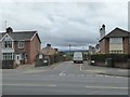
10
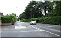
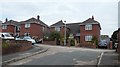
Topsham Road, at the junction with Feltrim Avenue
Image: © David Gearing
Taken: 24 Jun 2012
0.07 miles