IMAGES TAKEN NEAR TO
Matford Lane, EXETER, EX2 4PU
Introduction
This page details the photographs taken nearby to Matford Lane, EX2 4PU by members of the Geograph project.
The Geograph project started in 2005 with the aim of publishing, organising and preserving representative images for every square kilometre of Great Britain, Ireland and the Isle of Man.

There are currently over 7.5m images from over14,400 individuals and you can help contribute to the project by visiting https://www.geograph.org.uk
Image Map (Loading...)


Getting Data...Please wait
Leaflet Map data © OpenStreetMap
Images are licensed for reuse under creativecommons.org/licenses/by-sa/2.0
Notes
- Clicking on the map will re-center to the selected point.
- The higher the marker number, the further away the image location is from the centre of the postcode.
Image Listing (320 Images Found)
Images are licensed for reuse under creativecommons.org/licenses/by-sa/2.0
Image
Details
Distance
1
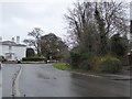
Junction of Matford Lane and Wonford Road, Exeter
Until the middle of the 20th century, the slightly staggered crossroads ahead had different priorities. Then Matford Lane curved to the right along the line of the vegetation and became Wonford Road, with two roads joining from the left and straight on and giving way. Now the junction has been realigned and traffic from Matford Lane gives way at the junction
Image: © David Smith
Taken: 1 Jan 2017
0.01 miles
2

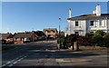
Junction of Matford Lane and Wonford Road, Exeter
Maps of this area dating from about 1900 show that the junction originally followed the wall behind the bushes on the left. At some stage the junction has been changed to be a right-angled T-junction, but the boundary of the property at the left remains. (This property is the Lord Mamhead Homes, administered by Exeter Municipal Charities.)
Image: © David Smith
Taken: 17 Jul 2009
0.02 miles
3
Wonford Road / Lyndhurst Road junction, Exeter
For a view up the road to the right, see Image The road on the left is Matford Lane.
Image: © Derek Harper
Taken: 25 Nov 2008
0.03 miles
4
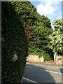
Entrance to convent and wasps' nest
The entrance to Mount St Mary convent in Lyndhurst Road with a wasps' nest in the hedge to the left
Image: © David Smith
Taken: 1 Aug 2019
0.03 miles
5
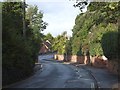
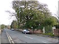
Wonford Road, Exeter
A bend in the road to the east of its junction with Matford Lane. The stone wall on the right is the wall of Mount St Mary convent
Image: © David Smith
Taken: 2 Nov 2013
0.03 miles
6
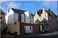
Modern and Victorian houses on Matford Lane, Exeter
A strikingly designed modern house seems to fit in rather well with its C19 neighbours in the St Leonard's area of Exeter, close to County Hall.
Image: © Derek Harper
Taken: 2 Oct 2006
0.04 miles
7

Matford Road
A view in the opposite direction to that in Image The cars are parked beside the wall of the Lord Mamhead Homes (Exeter Civic Charities) and the hedge on the left shields the grounds of that property. For some reason the wall does not extend for the full length of the property.
Image: © David Smith
Taken: 15 Sep 2012
0.04 miles
8
Lyndhurst Road, Exeter
The stone wall on the right is the boundary wall of Mount St Mary convent
Image: © David Smith
Taken: 13 Jan 2016
0.05 miles
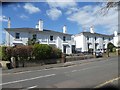
9
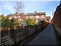
Road off Wonford Road, Exeter
These houses on Wonford Road have exceptionally long thin gardens.
Image: © Derek Harper
Taken: 28 Jan 2009
0.05 miles
10
Nineteenth century houses, Lyndhurst Road, Exeter
The nearer semi-detached houses have a blind window in the centre to create symmetry
Image: © David Smith
Taken: 29 Mar 2020
0.05 miles