IMAGES TAKEN NEAR TO
Wonford Road, EXETER, EX2 4PQ
Introduction
This page details the photographs taken nearby to Wonford Road, EX2 4PQ by members of the Geograph project.
The Geograph project started in 2005 with the aim of publishing, organising and preserving representative images for every square kilometre of Great Britain, Ireland and the Isle of Man.

There are currently over 7.5m images from over14,400 individuals and you can help contribute to the project by visiting https://www.geograph.org.uk
Image Map
Images are licensed for reuse under creativecommons.org/licenses/by-sa/2.0
Notes
- Clicking on the map will re-center to the selected point.
- The higher the marker number, the further away the image location is from the centre of the postcode.
Image Listing (308 Images Found)
Images are licensed for reuse under creativecommons.org/licenses/by-sa/2.0
Image
Details
Distance
1
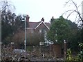
"Newstead", Matford Avenue, Exeter
One of the late Victorian houses in Matford Avenue it is now divided in two. Despite bomb damage, this house was used as part of St Loyes School of Occupational Therapy. See http://www2.plymouth.ac.uk/millbrook/millhist/origins.htm
Image: © David Smith
Taken: 5 Feb 2009
0.01 miles
2
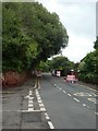
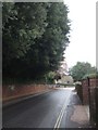
Wonford Road, Exeter
The old Heavitree stone wall on the left is the boundary of Larkby Young People's Unit run by the NHS
Image: © David Smith
Taken: 6 Oct 2013
0.01 miles
3

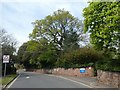
Wonford Road, Exeter
A rather charming road, here bordering (on the right) the grounds of Evergreen House and Matford Lodge, Victorian houses which are now occupied by Devon Primary Care Trust Child and Adolescent Mental Health Services.
Image: © Derek Harper
Taken: 25 Nov 2008
0.02 miles
4
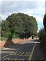
Pop-up cycle lane, Wonford Road, Exeter
A pop-up road closure with access for buses and cycles, to encourage cycling in Exeter and prevent the road being used as a rat-run
Image: © David Smith
Taken: 11 Jun 2020
0.02 miles
5

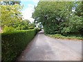
Deepdene Park, Exeter
A private road, leading south from Wonford Road, Exeter
Image: © David Smith
Taken: 14 Feb 2010
0.03 miles
6
Deepdene Park
Deepdene Park is a private road leading to several houses which are built on the land of a former (plant) nursery. Most have large gardens. At the north end, the road joins Wonford Road
Image: © David Smith
Taken: 16 Jul 2011
0.03 miles
7
Wonford Road
On the left is an old boundary wall; opposite are mainly post-WW2 houses.
Image: © David Smith
Taken: 10 Dec 2010
0.03 miles
8
Trees and wall of Larkby, Wonford Road, Exeter
Image: © David Smith
Taken: 12 Apr 2020
0.03 miles
9
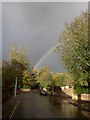
Rainbow over Exeter
The end of the rainbow is close to Magdalen Court School amidst the trees.
Image: © David Smith
Taken: 13 Oct 2012
0.04 miles
10
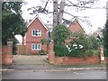
Modern house in Matford Avenue, Exeter
The architect's brief for this 21st century house was "A house with modern facilities, that will not look out of place in a street with Victorian houses". It was built in half of the garden of the neighbouring (Victorian) house.
Image: © David Smith
Taken: 5 Feb 2009
0.04 miles