IMAGES TAKEN NEAR TO
Matford Road, EXETER, EX2 4PE
Introduction
This page details the photographs taken nearby to Matford Road, EX2 4PE by members of the Geograph project.
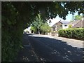
The Geograph project started in 2005 with the aim of publishing, organising and preserving representative images for every square kilometre of Great Britain, Ireland and the Isle of Man.

There are currently over 7.5m images from over14,400 individuals and you can help contribute to the project by visiting https://www.geograph.org.uk
Image Map
Images are licensed for reuse under creativecommons.org/licenses/by-sa/2.0
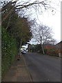
Notes
- Clicking on the map will re-center to the selected point.
- The higher the marker number, the further away the image location is from the centre of the postcode.
Image Listing (311 Images Found)
Images are licensed for reuse under creativecommons.org/licenses/by-sa/2.0
Image
Details
Distance
1
Matford Road, Exeter
Looking in the opposite direction to Image, showing a house with solar panels
Image: © David Smith
Taken: 9 Jun 2013
0.01 miles
2

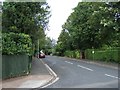
Matford Road
A view in the opposite direction to that in Image The cars are parked beside the wall of the Lord Mamhead Homes (Exeter Civic Charities) and the hedge on the left shields the grounds of that property. For some reason the wall does not extend for the full length of the property.
Image: © David Smith
Taken: 15 Sep 2012
0.02 miles
3

Matford Road, Exeter
On the right is the boundary wall of the Lord Mamhead Homes (managed by a civic charity), housed in a Victorian building; opposite are more modern houses,but the walls predate the houses.
Image: © David Smith
Taken: 10 Dec 2010
0.02 miles
4
Matford Road, St Leonard's, Exeter
On the left are the hedges and boundaries of two large Victorian houses; on the right are twentieth century houses with walls.
Image: © David Smith
Taken: 30 Nov 2012
0.02 miles
5

Wonford Road, Exeter
At the centre of the photograph is a Victorian stable building, which is now used as a garage and workroom. The house to which it belonged has been replaced with a mid-20th century house.
Image: © David Smith
Taken: 13 Feb 2009
0.03 miles
6
Matford Road, Exeter
A quiet residential road in St Leonard's, Exeter. It is one of the increasingly rare urban roads which do not have house numbers, only names.
Image: © David Smith
Taken: 31 Aug 2009
0.04 miles
7

Wonford Road, Exeter at Midday
Taken as the clock on County Hall struck noon on Christmas Day. This is from the same position as Image and shows that in the intervening twelve months, building work has started next to the coach house/stables. The work is to add a second storey to a post-war bungalow. The coach house belonged to a house which was damaged in the Exeter Blitz of 1942; a new house was built on the site.
Image: © David Smith
Taken: 25 Dec 2012
0.04 miles
8
Wonford Road, Exeter
A bend in the road to the east of its junction with Matford Lane. The stone wall on the right is the wall of Mount St Mary convent
Image: © David Smith
Taken: 2 Nov 2013
0.05 miles
9

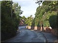
Junction of Matford Lane and Wonford Road, Exeter
Maps of this area dating from about 1900 show that the junction originally followed the wall behind the bushes on the left. At some stage the junction has been changed to be a right-angled T-junction, but the boundary of the property at the left remains. (This property is the Lord Mamhead Homes, administered by Exeter Municipal Charities.)
Image: © David Smith
Taken: 17 Jul 2009
0.05 miles
10
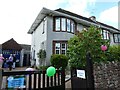
House advertising open garden for charity, Exeter
Image: © David Smith
Taken: 12 Jun 2022
0.05 miles