IMAGES TAKEN NEAR TO
Barnardo Road, EXETER, EX2 4NE
Introduction
This page details the photographs taken nearby to Barnardo Road, EX2 4NE by members of the Geograph project.
The Geograph project started in 2005 with the aim of publishing, organising and preserving representative images for every square kilometre of Great Britain, Ireland and the Isle of Man.

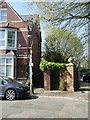
There are currently over 7.5m images from over14,400 individuals and you can help contribute to the project by visiting https://www.geograph.org.uk
Image Map (Loading...)


Getting Data...Please wait
Leaflet Map data © OpenStreetMap
Images are licensed for reuse under creativecommons.org/licenses/by-sa/2.0
Notes
- Clicking on the map will re-center to the selected point.
- The higher the marker number, the further away the image location is from the centre of the postcode.
Image Listing (491 Images Found)
Images are licensed for reuse under creativecommons.org/licenses/by-sa/2.0
Image
Details
Distance
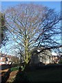
1
Barnardo Road, Exeter
From the other end of Image, where it meets St Leonard's Place. The houses face Image The spire belongs to Image
Image: © Derek Harper
Taken: 1 Dec 2008
0.03 miles
2
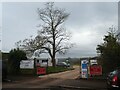
Construction work, Mount Radford Lawn, Exeter
Mount Radford Lawn was part of the estate of the long-ago demolished Mount Radford House; Barnardo Road Image houses occupy the site of the building. The green space was used as a playing field by the Deaf Academy; the work is to improve the water supply and drainage for the housing estate planned for the site of that school.
Image: © David Smith
Taken: 9 Dec 2020
0.03 miles
3

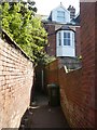
Back alleyway between Barnardo and Cedars Roads, Exeter
Image: © David Smith
Taken: 10 Apr 2020
0.04 miles
4
Service alleyway for houses in Barnardo Road, Exeter
Image: © David Smith
Taken: 26 Dec 2019
0.04 miles
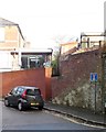
5
The corner of Barnardo Road and St Leonard's Place, Exeter
On the right are the gates to "The Cedars" and behind the lamppost is the alleyway to Cedars Road
Image: © David Smith
Taken: 10 Apr 2020
0.04 miles
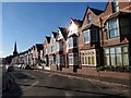
6

Barnardo Road, Exeter
This road is parallel to Image, and is connected to Topsham Road by a smimilar double bend.
Image: © Derek Harper
Taken: 1 Dec 2008
0.04 miles
7

Holloway Street and Cedars Road, Exeter
Holloway Street is the extension of Topsham Road towards the city centre, and the street crosses the valley of the Shutebrook. The houses of Cedars Road are on the eastern side of the valley. The retaining wall surrounds the rear gardens of houses in Barnardo Road, and dates from the time when Mount Radford House dominated the area.
Image: © David Smith
Taken: 9 Nov 2013
0.05 miles
8

Cedars Road
The Victorian houses of Cedars Road are back to back with Barnardo Road. The service alley way can just be seen. The retaining wall surrounds the rear gardens of houses in Barnardo Road, and dates from the time when Mount Radford House dominated the area.
The wall's repair has now been finished. See Image
Image: © Anthony Vosper
Taken: 5 Aug 2014
0.05 miles
9
Alleyway from Cedars Road to Barnardo Road, Exeter
Image: © David Smith
Taken: 10 Apr 2020
0.05 miles