IMAGES TAKEN NEAR TO
Magdalen Street, EXETER, EX2 4HN
Introduction
This page details the photographs taken nearby to Magdalen Street, EX2 4HN by members of the Geograph project.
The Geograph project started in 2005 with the aim of publishing, organising and preserving representative images for every square kilometre of Great Britain, Ireland and the Isle of Man.

There are currently over 7.5m images from over14,400 individuals and you can help contribute to the project by visiting https://www.geograph.org.uk
Image Map
Images are licensed for reuse under creativecommons.org/licenses/by-sa/2.0
Notes
- Clicking on the map will re-center to the selected point.
- The higher the marker number, the further away the image location is from the centre of the postcode.
Image Listing (999 Images Found)
Images are licensed for reuse under creativecommons.org/licenses/by-sa/2.0
Image
Details
Distance
1
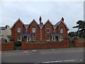
Victorian almshouses, Magdalen Street, Exeter
Image: © David Smith
Taken: 29 Sep 2013
0.00 miles
2
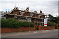
Magdalen Street almshouses
Currently undergoing refurbishment.
Image: © Bill Boaden
Taken: 29 Jun 2011
0.01 miles
3
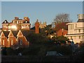
Buildings north of Magdalen Street, Exeter
This is quite a similar view to Image, but taken from Fairpark Road. Similarly, Exeter Combined Court Centre is on the right, the south tower of the cathedral tower is in the centre, and on the left is the Halford wing of Dean Clarke House. Nearer at hand are almshouses between Magdalen Street and Pavilion Place, with tall brick chimneys.
Image: © Derek Harper
Taken: 19 Nov 2008
0.02 miles
4
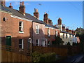
Pavilion Place, Exeter
A terraced back street tucked away off Magdalen Street.
Image: © Derek Harper
Taken: 21 Nov 2006
0.03 miles
5

Magdalen Street, Exeter
The street crosses the valley of the Larkbeare Brook, occupied below the retaining wall by Bull Meadow park. The roadway was levelled as long ago as 1599. The large building on the left is the Hotel Barcelona, formerly the West of England Eye Infirmary. On the right is a terrace of gabled almshouses.
Image: © Derek Harper
Taken: 21 Nov 2006
0.03 miles
6

Exeter from Western Way
Or from the point where the inner bypass swings round to become Magdalen Street, looking over the rooftops of Image On the right is the new Exeter Combined Court Centre, with the south cathedral tower peeking around the corner. On the left is the Halford wing (1856) of Dean Clarke House, the original Royal Devon and Exeter Hospital.
Image: © Derek Harper
Taken: 21 Nov 2006
0.03 miles
7
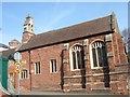
The chapel of Wynard's Almshouses
The almshouses have been converted into residences.
Image: © David Smith
Taken: 10 Apr 2010
0.03 miles
8

Construction work in Bull Meadow, Exeter
The grass of the playing field has been stripped away in readiness for the replacement of a leaking drain.
Image: © David Smith
Taken: 15 Jun 2022
0.03 miles
9
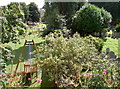
Rest and play
Looking down from the road to Bull Meadow - a burial ground and children's playground cheek by jowl. The burial ground is an old Jewish site and the meadow to the left was the site of St Mary Magdalen's Hospital - a twelfth century establishment to care for lepers. It was deliberately built outside the city walls and patients were forbidden to enter the gates on market days. In 1435 a William Wynard converted it to caring for the poor and infirm as well as priests. The hospital is long gone but the road is named after it - Magdalen Street.
Image: © Neil Owen
Taken: 20 Aug 2014
0.04 miles
10
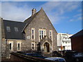
Friends Meeting House, Exeter
The Quakers have moved several times in Exeter since freedom of worship arrived in 1690. This building dates from 1876. http://www.pastscape.org.uk/hob.aspx?hob_id=1485720 To the right is Exeter Combined Court Centre.
Image: © Derek Harper
Taken: 21 Nov 2006
0.04 miles