IMAGES TAKEN NEAR TO
Commercial Road, EXETER, EX2 4ED
Introduction
This page details the photographs taken nearby to Commercial Road, EX2 4ED by members of the Geograph project.
The Geograph project started in 2005 with the aim of publishing, organising and preserving representative images for every square kilometre of Great Britain, Ireland and the Isle of Man.

There are currently over 7.5m images from over14,400 individuals and you can help contribute to the project by visiting https://www.geograph.org.uk
Image Map
Images are licensed for reuse under creativecommons.org/licenses/by-sa/2.0
Notes
- Clicking on the map will re-center to the selected point.
- The higher the marker number, the further away the image location is from the centre of the postcode.
Image Listing (1001 Images Found)
Images are licensed for reuse under creativecommons.org/licenses/by-sa/2.0
Image
Details
Distance
1
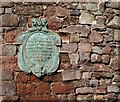
Exeter city?s west gate.
This plaque commemorates the original location of Exeter city’s west gate. It is near ‘The House That Moved’ and St Mary Steps church. It also commemorates some of the military campaigns in which it featured.
Image: © Anthony Volante
Taken: 26 Feb 2010
0.01 miles
2
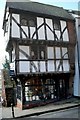
The House that Moved in Exeter
The House that Moved is at Stepcote Hill beside St Mary Steps Church, Exeter. It is a small timber-framed house dating from 1471, one room wide but three storeys high. It created a bit of a sensation when it was threatened by road expansion in 1961. Rather than demolish it they decided to move it! It was put on rollers and moved to its current location, some 70 metres (75 yards) from the original place.
Image: © Anthony Volante
Taken: 26 Feb 2010
0.02 miles
3

Exeter: Old Warehouses by the Quay
These buildings were two clubs and a restaurant on the quay, called Tiffany's and Mambo. The clubs have now closed. Even earlier in the mid-1960s, the building was called The Quay Club. In the late 1960s it was host to the Radio One Club.
Image: © Mr Eugene Birchall
Taken: 8 Apr 2010
0.03 miles
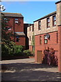
4
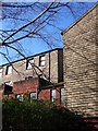
Gabriel Court, Exeter
Another section of the housing shown in Image and Image, showing a grey tile-hung terrace. Designed by the successful 1970s firm Marshman Warren Taylor, now Kensington Taylor.
Image: © Derek Harper
Taken: 14 Feb 2007
0.03 miles
6
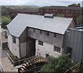
Weaver's Court, Exeter
Modern housing on Shilhay, built in the late 1970's on land beside the River Exe. Until flood prevention was put in place in the 60s and 70s, residential development here would have been difficult.
Image: © Derek Harper
Taken: 25 Sep 2006
0.04 miles
7
Silt on edge of River Exe, on inside of bend
In February 2008, the Environment Agency carried out survey and dredging work on the River Exe between Millers Bridge (SX914926) and Trews Weir (SX924915) which meant that the river level was lowered by between 1 and 2 metres. This is one of a set of pictures showing the river in such unusual circumstances. The pictures of the quay form a panorama showing some of the bedrock on which the quay was built.
Image: © David Smith
Taken: 15 Feb 2008
0.04 miles
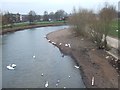
8

Swans on the Exe Christmas 2008
Swans a-swimming on a peaceful river Exe Christmas day 2008.
Image: © Jan Baker
Taken: 25 Dec 2008
0.04 miles
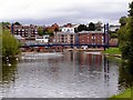
9

Buildings on Exeter Quay from above
Taken looking down from the pathway beside the city walls (to the right). The side of the Customs House is on the right; Cricklepit Bridge is beyond the warehouse; and the Haven Banks flats are on the left over the river. Beyond is St Thomas.
Image: © Derek Harper
Taken: 10 Oct 2006
0.05 miles
10
River Exe, Cricklepit Bridge
This footbridge across the River Exe was built in 1988 to link the quayside with Haven Banks. Photo from Haven Bank.
Image: © David Dixon
Taken: 14 Aug 2009
0.05 miles