IMAGES TAKEN NEAR TO
Newbery Close, COLYTON, EX24 6TJ
Introduction
This page details the photographs taken nearby to Newbery Close, EX24 6TJ by members of the Geograph project.
The Geograph project started in 2005 with the aim of publishing, organising and preserving representative images for every square kilometre of Great Britain, Ireland and the Isle of Man.

There are currently over 7.5m images from over14,400 individuals and you can help contribute to the project by visiting https://www.geograph.org.uk
Image Map
Images are licensed for reuse under creativecommons.org/licenses/by-sa/2.0
Notes
- Clicking on the map will re-center to the selected point.
- The higher the marker number, the further away the image location is from the centre of the postcode.
Image Listing (18 Images Found)
Images are licensed for reuse under creativecommons.org/licenses/by-sa/2.0
Image
Details
Distance
1
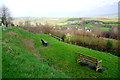
Viewpoint over Colyton
These seats which have a car park and a picnic area to go with them have a splendid view over the small town and the adjacent Axe valley.
Image: © Nigel Mykura
Taken: 3 Feb 2016
0.14 miles
2

Path by the Coly
The river is only a few metres to the right of Colyton Footpath 7 as it heads down the left bank, but can't be seen here for trees and bushes.
Image: © Derek Harper
Taken: 19 Jun 2012
0.15 miles
3

The River Coly
A short section that has not been colonised by Himalayan Balsam or Japanese Knotweed though there are extensive areas of both nearby.
Image: © Jonathan Thacker
Taken: 5 Sep 2014
0.15 miles
4

Colyton : South Street B3161
Looking down South Street which heads out of Colyton.
Image: © Lewis Clarke
Taken: 16 Feb 2012
0.16 miles
5
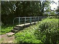
Footbridge across the Coly
Colyton Footpath 7 crosses this footbridge to meet the B3161 at the southern end of Colyton; meanwhile Colyton Footpath 27 turns away and continues along the left bank of the river. A bank of nettles on the right.
Image: © Derek Harper
Taken: 19 Jun 2012
0.17 miles

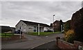
7
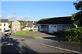
Grove Hill Colyton
Grove Hill is a short residential cul-de-sac lined with small semidetached houses and some maisonettes off South St, the B3161 which can be seen in the background. This building is Colyton Health Centre.
Image: © Nigel Mykura
Taken: 7 Oct 2017
0.18 miles
8
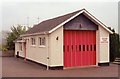
Colyton Fire Station
Colyton Fire Station, South Street, Colyton, Devon.
Image: © Kevin Hale
Taken: 30 Jun 1991
0.18 miles
9

Colyton : Colyton Community Fire Station
Colyton Community Fire Station based on South Street.
Image: © Lewis Clarke
Taken: 16 Feb 2012
0.18 miles
10
Colyton : Colyton Health Centre
A health centre based on Grove Hill in Colyton.
Image: © Lewis Clarke
Taken: 16 Feb 2012
0.18 miles